
湘潭县 topographic map
Interactive map
Click on the map to display elevation.
About this map
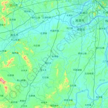
Name: 湘潭县 topographic map, elevation, terrain.
Location: 湘潭县, 湘潭市, 湖南省, 中国 (27.34181 112.41524 27.94545 113.05326)
Average elevation: 90 m
Minimum elevation: 27 m
Maximum elevation: 715 m
位于湖南省中部偏东,湘江下游。地形以丘陵和平原为主,地势西南高,东北低。境内最高点为海拔755米的昌山。
Other topographic maps
Click on a map to view its topography, its elevation and its terrain.