
社港镇 topographic map
Interactive map
Click on the map to display elevation.
About this map
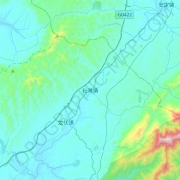
Name: 社港镇 topographic map, elevation, terrain.
Location: 社港镇, 浏阳市, 长沙市, 湖南省, 中国 (28.40316 113.43900 28.54160 113.69943)
Average elevation: 209 m
Minimum elevation: 68 m
Maximum elevation: 1,330 m
Other topographic maps
Click on a map to view its topography, its elevation and its terrain.