
绥宁县 topographic map
Interactive map
Click on the map to display elevation.
About this map
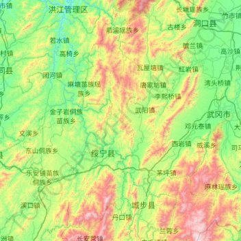
Name: 绥宁县 topographic map, elevation, terrain.
Location: 绥宁县, 邵阳市, 湖南省, 中国 (26.26030 109.82222 27.14625 110.53517)
Average elevation: 621 m
Minimum elevation: 157 m
Maximum elevation: 1,997 m
绥宁县北靠雪峰山脉,南依大南山;主要山峰有宝顶山、牛坡头、鸡公坡和神坡山,其中牛坡头海拔1913米,为辖境至高点。地势东南、北部高,东北和西部较低,辖境最低点海拔227米。境内有大小溪流94条,主要河流为巫水和武阳河。
Other topographic maps
Click on a map to view its topography, its elevation and its terrain.