
渌口区 topographic map
Interactive map
Click on the map to display elevation.
About this map
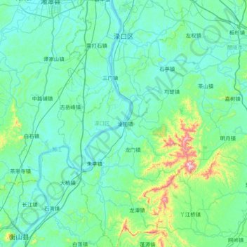
Name: 渌口区 topographic map, elevation, terrain.
Location: 渌口区, 株洲市, 湖南省, 中国 (27.20777 112.96396 27.78343 113.31208)
Average elevation: 113 m
Minimum elevation: 26 m
Maximum elevation: 787 m
渌口区是湖南省株洲市的一个市辖区,位于湖南省中部偏东,湘江中游,地形东西窄,南北长。区境北连株洲市天元区、芦淞区和浏阳市,西接湘潭市市区和湘潭县,东邻醴陵市,南界攸县和衡东县。全区总面积1053.6平方公里,总人口約27万人。縣人民政府驻地为渌口镇。2018年6月,国务院正式批复同意撤销株洲县,以原株洲县的行政区域设立株洲市渌口区。
Other topographic maps
Click on a map to view its topography, its elevation and its terrain.