
Region Norrland topographic map
Interactive map
Click on the map to display elevation.
Region Norrland
Norrland has a highly variable climate depending on altitude, latitude and distance to water. The southern coastal areas have a humid continental climate, but further north, the subarctic climate is abundant, although it in many areas is very mild for that classification, especially in coastal regions. In the mountain ranges the tundra climate can be found with summer temperatures averaging below 10 °C (50 °F), but that is due to altitude and not in populated areas. All low-lying areas of Norrland are below the tree line because of the mild summers and so the boreal forest is dominant.
About this map
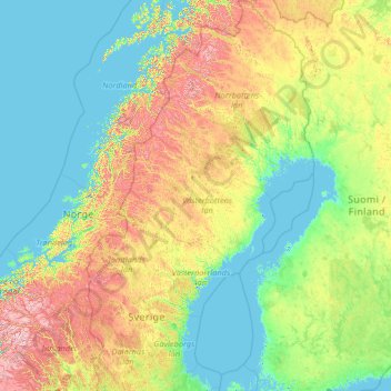
Name: Region Norrland topographic map, elevation, terrain.
Location: Region Norrland, Sweden (60.16955 11.97458 69.05997 24.17768)
Average elevation: 270 m
Minimum elevation: -3 m
Maximum elevation: 2,236 m
Other topographic maps
Click on a map to view its topography, its elevation and its terrain.
Skövde
Sweden > Västra Götaland County
Skövde has a maritime-continental hybrid climate. The town is influenced by being in the slope of a hill, which leads to warmer overnight lows than in Skara on the western side of the same higher area. In July 2018, Skövde recorded a 22 °C (72 °F) mean during the 2018 European heat wave. This makes it one…
Average elevation: 181 m
Abisko
Permafrost is common around the village albeit this low altitude permafrost is disappearing because of global warming and increased snowfall.
Average elevation: 395 m