
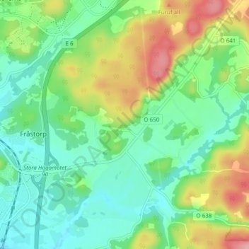
Spekeröd topographic map
Interactive map
Click on the map to display elevation.
About this map
Name: Spekeröd topographic map, elevation, terrain.
Average elevation: 44 m
Minimum elevation: 3 m
Maximum elevation: 127 m
Other topographic maps
Click on a map to view its topography, its elevation and its terrain.
Skövde
Sweden > Västra Götaland County
Skövde, Skövde kommun, Västra Götaland County, 541 30, Sweden
Average elevation: 182 m
Norra Björke
Sweden > Västra Götaland County
Norra Björke, Trollhättans kommun, Västra Götaland County, Sweden
Average elevation: 63 m
Dals Långed
Sweden > Västra Götaland County
Dals Långed, Bengtsfors kommun, Västra Götaland County, 666 95, Sweden
Average elevation: 130 m
Torreby
Sweden > Västra Götaland County
Torreby, Munkedals kommun, Västra Götaland County, 455 91, Sweden
Average elevation: 39 m
Vänersborg
Sweden > Västra Götaland County > Vänersborg
Vänersborg, Vänersborgs kommun, Västra Götaland County, 462 80, Sweden
Average elevation: 58 m