Geolocate

Rusksele topographic map

Interactive map

Click on the map to display elevation.

About this map

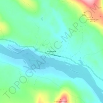
Name: Rusksele topographic map, elevation, terrain.

Location: Rusksele, Lycksele kommun, Västerbotten County, Sweden (64.79507 18.87926 64.83507 18.91926)

Average elevation: 249 m

Minimum elevation: 216 m

Maximum elevation: 374 m

Other topographic maps

Click on a map to view its topography, its elevation and its terrain.

Lycksele kommun

Sweden > Västerbotten County

Lycksele kommun, Västerbotten County, Sweden

Average elevation: 356 m

Skelleftehamn

Sweden > Västerbotten County

Skelleftehamn, Skellefteå kommun, Västerbotten County, 932 33, Sweden

Average elevation: 6 m

Klutmark

Sweden > Västerbotten County

Klutmark, Skellefteå kommun, Västerbotten County, Sweden

Average elevation: 75 m

Adak

Sweden > Västerbotten County

Adak, Malå kommun, Västerbotten County, Sweden

Average elevation: 410 m

Agnäs

Sweden > Västerbotten County > Bjurholm District

Agnäs, Bjurholm District, Bjurholms kommun, Västerbotten County, Sweden

Average elevation: 149 m