
八塘镇 topographic map
Interactive map
Click on the map to display elevation.
About this map
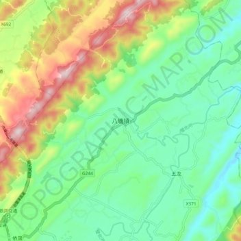
Name: 八塘镇 topographic map, elevation, terrain.
Location: 八塘镇, 璧山区, 重庆市, 中国 (29.79740 106.25150 29.87740 106.33150)
Average elevation: 387 m
Minimum elevation: 210 m
Maximum elevation: 747 m
Other topographic maps
Click on a map to view its topography, its elevation and its terrain.