Geolocate

金鸡镇 topographic map

Interactive map

Click on the map to display elevation.

About this map

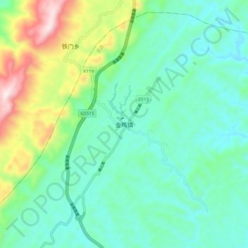
Name: 金鸡镇 topographic map, elevation, terrain.

Location: 金鸡镇, 忠县, 重庆市, 中国 (30.43767 107.68997 30.51767 107.76997)

Average elevation: 579 m

Minimum elevation: 409 m

Maximum elevation: 1,081 m

Other topographic maps

Click on a map to view its topography, its elevation and its terrain.

洋渡镇

中国 > 重庆市 > 忠县

洋渡镇, 忠县, 重庆市, 中国

Average elevation: 260 m

复兴镇

中国 > 重庆市 > 忠县

复兴镇, 忠县, 重庆市, 中国

Average elevation: 236 m

马灌镇

中国 > 重庆市 > 忠县

马灌镇, 忠县, 重庆市, 中国

Average elevation: 488 m

三峡水库

中国 > 重庆市 > 忠县

三峡水库, 忠县, 渝东北三峡库区城镇群, 重庆市, 中国

Average elevation: 782 m

忠县

中国 > 重庆市 > 忠县

忠县, 渝东北三峡库区城镇群, 重庆市, 中国

Average elevation: 443 m

忠州镇

中国 > 重庆市 > 忠县 > 忠州镇

忠州镇, 忠县, 渝东北三峡库区城镇群区位, 重庆市, 中国

Average elevation: 263 m