Geolocate

平安镇 topographic map

Interactive map

Click on the map to display elevation.

About this map

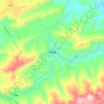
Name: 平安镇 topographic map, elevation, terrain.

Location: 平安镇, 云阳县, 重庆市, 中国 (30.99668 108.46339 31.07668 108.54339)

Average elevation: 519 m

Minimum elevation: 184 m

Maximum elevation: 1,111 m

Other topographic maps

Click on a map to view its topography, its elevation and its terrain.

江口镇

中国 > 重庆市 > 云阳县

江口镇, 云阳县, 重庆市, 中国

Average elevation: 419 m

水口乡

中国 > 重庆市 > 云阳县

水口乡, 云阳县, 重庆市, 中国

Average elevation: 504 m

黄石镇

中国 > 重庆市 > 云阳县

黄石镇, 云阳县, 渝东北三峡库区城镇群区位, 重庆市, 中国

Average elevation: 412 m

故陵镇

中国 > 重庆市 > 云阳县

故陵镇, 云阳县, 渝东北三峡库区城镇群区位, 重庆市, 中国

Average elevation: 425 m

云阳县

中国 > 重庆市 > 云阳县

云阳县, 渝东北三峡库区城镇群, 重庆市, 中国

Average elevation: 483 m