
重庆市 topographic map
Interactive map
Click on the map to display elevation.
About this map
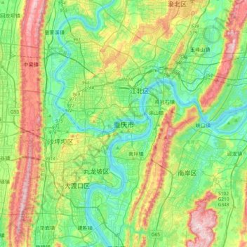
Name: 重庆市 topographic map, elevation, terrain.
Location: 重庆市, 渝中区, 重庆市, 400014, 中国 (29.40567 106.38792 29.72567 106.70792)
Average elevation: 318 m
Minimum elevation: 148 m
Maximum elevation: 681 m
重庆市属亚热带季风气候,每年平均气温约在14-18℃之间。主城区年平均气温为18.2℃,东南部酉阳土家族自治县14.9℃,东北部海拔较高的城口仅13.7℃。最热月份平均气温26-29℃,最冷月平均气温2-8℃,气温呈现出由西部河谷及沿江地带向东北部、东南部递减的趋势。1951-2017年日最高温≥40℃天数90天,居全国省会级大城市首位,是“三大火炉”之一。
Other topographic maps
Click on a map to view its topography, its elevation and its terrain.