
霞坑镇 topographic map
Interactive map
Click on the map to display elevation.
About this map
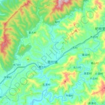
Name: 霞坑镇 topographic map, elevation, terrain.
Location: 霞坑镇, 歙县, 黄山市, 安徽省, 中国 (29.91416 118.58832 30.03328 118.70299)
Average elevation: 293 m
Minimum elevation: 110 m
Maximum elevation: 824 m
Other topographic maps
Click on a map to view its topography, its elevation and its terrain.