Geolocate

Eastern Development Region topographic map

Interactive map

Click on the map to display elevation.

About this map

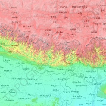
Name: Eastern Development Region topographic map, elevation, terrain.

Location: Eastern Development Region, Nepal (24.81597 84.80629 30.01597 90.00629)

Average elevation: 2,441 m

Minimum elevation: 9 m

Maximum elevation: 8,419 m

Other topographic maps

Click on a map to view its topography, its elevation and its terrain.

Machhapuchchhre

Nepal > Gandaki Province > Kaski

Average elevation: 3,545 m

Dhankuta

Nepal > Koshi Province

Dhankuta is a mid-hill district of eastern hill region of Nepal. It is situated between 26°53' to 27°19' north latitude and 87°8' to 88°33' east longitude. Total area of the district is 888.7 square kilometres (343.1 sq mi) and it is located at 243 metres (9,600 in) to 629 metres (24,800 in) of elevation…

Average elevation: 1,098 m

Dadeldhura

Nepal > Sudurpashchim Province

Average elevation: 1,234 m

Biratnagar

Nepal > Koshi Province > Morang

Average elevation: 70 m

Dharan

Nepal > Koshi Province > Sunsari

Dharan is situated on the foothills of the Mahabharat Range in the north with its southern tip touching the edge of the Terai region at an altitude of 1148 ft (349m). Dharan bazaar grew up near Phusre where the old walking route to Dhankuta and a large part of the Eastern hills left the plains with the ascent…

Average elevation: 499 m

Rolpa

Nepal > Lumbini Province

Average elevation: 1,793 m

Rishing

Nepal > Gandaki Province > Tanahun

Average elevation: 585 m

Bhojpur

Nepal > Koshi Province

Classified as a hill district, Bhojpur actually spans five of Nepal's eight climate zones. 3% of the district's area is below 300 meters elevation in the Lower Tropical zone and 31% is Upper Tropical from 300 to 1,000 meters. 50% of the land area belongs to the Subtropical Zone between 1,000 and 2,000 meters…

Average elevation: 1,352 m

Khandbari

Nepal > Koshi Province > Sankhuwasabha

Average elevation: 857 m

Dang

Nepal > Lumbini Province

The Dudhwas rise steeply to a crest at about 700 meters, then slope more gradually into the Deukhuri Valley, down to 250 meters elevation at the Rapti River. The Dudhwas extend more than 100 km, causing the Rapti to detour west around them before turning southeast down the main trend of the plains into India.…

Average elevation: 746 m

Dhangadhi

Nepal > Kailali

Average elevation: 178 m

Kaski

Nepal > Gandaki Province

The district, with Pokhara as its district headquarter, covers an area of 2,017 square km and had a total population of 492,098 according to 2011 Census. This district lies at the centroid point of the country. The altitude of Kaski district ranges from 450 meters the lowest land to 8091 meters the highest…

Average elevation: 2,565 m

Kailali

Nepal

Average elevation: 516 m

Doti

Nepal

Average elevation: 1,451 m

Janaknandani

Nepal > Madhesh Province > Dhanusha

Average elevation: 73 m

Mahottari

Nepal > Madhesh Province > Mahottari

Average elevation: 71 m

Mahottari

Nepal > Madhesh Province

Average elevation: 174 m

Modi Rural Municipality Ward No.4

Nepal > Parbat

Average elevation: 1,925 m

Laligurans

Nepal > Tehrathum

Average elevation: 1,802 m

Pokhara

Nepal > Gandaki Province > Kaski

Pokhara (Nepali: पोखरा, Nepali pronunciation: [ˈpokʰʌɾa]) is a metropolitan city in central Nepal, which serves as the capital of Gandaki Province. It is the second most populous city of Nepal after Kathmandu, with 518,452 inhabitants living in 101,669 households in 2021. It is the country's…

Average elevation: 1,203 m

Brindaban

Nepal > Rautahat

Average elevation: 107 m

Rakha Bangdel

Nepal > Khotang

Average elevation: 2,047 m

Dhading

Nepal > Dhading

Average elevation: 1,704 m

Arjun Khola

Nepal > Dang > Satbariya

Average elevation: 385 m

Duduwa

Nepal > Banke

Average elevation: 150 m

Banjaraha

Nepal > Rautahat

Average elevation: 74 m

Udayapur

Nepal

This inner Terai district (low mid-hills) covers elevations between 360 metres to 2310 metres above sea level. Different topography, geology and altitude have established three distinct physiographic zones in the district as mentioned below.

Average elevation: 672 m

Far-Western Development Region

Nepal

The Far-Western Region covered 19,539 square kilometers. It had nine districts with the regional headquarters at Dipayal, Doti district. The Far-Western Region was remote and developmentally challenged. Some 44% of people in the Far West Hills and 49% in the Himalayan districts lived below the poverty line.…

Average elevation: 1,858 m

Batase

Nepal > Batase

Average elevation: 1,263 m

Khumbu Glacier

Nepal > Solukhumbu > Khumjung

The Khumbu Glacier (Nepali: खुम्बु हिमनदी) is located in the Khumbu region of northeastern Nepal between Mount Everest and the Lhotse-Nuptse ridge. With elevations of 4,900 m (16,100 ft) at its terminus to 7,600 m (24,900 ft) at its source, it is the world's highest glacier. The Khumbu…

Average elevation: 6,296 m

Nuwakot

Nepal

Average elevation: 1,805 m

Banakhu Chor

Nepal > Banakhu Chor

Average elevation: 969 m

Gorkha

Nepal

Average elevation: 787 m

Dharapani

Nepal > Province #5 > Dharapani

Average elevation: 1,195 m

Karnali Province

Nepal

Average elevation: 3,366 m

Bagmati

Nepal > Province #2

Average elevation: 148 m

Halesi Tuwachung

Nepal

Average elevation: 1,041 m

Gajuri

Nepal

Average elevation: 1,068 m

Bandipur

Nepal > Bandipur

Bandipur is located at 27.56 N, 84.25 E and an elevation of 1030m on a mountain saddle (Mahabharat range) approximately 700m above the Marsyangdi River Valley, 143 km to the west of Kathmandu and 80 km to the east of Pokhara. Since 1998 it is connected by an 8 km access road from Dumre (Prithvi Highway). Until…

Average elevation: 738 m

Haripur

Nepal

Average elevation: 112 m

Bhanu

Nepal > Bhanu

Average elevation: 606 m

Kanpur Kalapani

Nepal > Kanpur Kalapani

Average elevation: 1,298 m

Gorkha

Nepal

Average elevation: 2,862 m

Baireni

Nepal > Baireni

Average elevation: 949 m

Chheskam

Nepal > Chheskam

Average elevation: 4,213 m

Janakpur

Nepal

Average elevation: 76 m

Surkhet

Nepal > Mid-Western Development Region

Average elevation: 958 m

Haripurwa

Nepal > Sarlahi > Haripurwa

Average elevation: 97 m