
Halesi Tuwachung topographic map
Interactive map
Click on the map to display elevation.
About this map
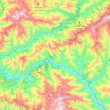
Name: Halesi Tuwachung topographic map, elevation, terrain.
Location: Halesi Tuwachung, Khotang, Province #1, Nepal (27.08834 86.42649 27.24634 86.75115)
Average elevation: 1,041 m
Minimum elevation: 245 m
Maximum elevation: 2,290 m
Other topographic maps
Click on a map to view its topography, its elevation and its terrain.
Khumjung
Nepal > Koshi Province > Solukhumbu
Khumjung (Nepali: खुम्जुंग) is a village in Khumbu Pasanglhamu rural municipality of Solukhumbu District in Province No. 1 of north-eastern Nepal. It is located in the Khumbu subregion inside Sagarmatha National Park, a world heritage site. The village is at an elevation of 3,790 metres above…
Average elevation: 3,888 m
Tengboche
Nepal > Solukhumbu > Khumjung > Tengboche
Tengboche is a midway station on the trail to the base camp for the mountain climbers of Mount Everest and other peaks of over 8,000 metres (26,000 ft) elevation; all these areas form part of the entire Khumbu region up to Tibet border with an area of 1,148 square kilometres (443 sq mi) encompassing Sagarmatha…
Average elevation: 3,936 m
Mount Everest
Nepal > Koshi Province > Solukhumbu
Mount Everest (Nepali: सगरमाथा, romanized: Sagarmāthā; Tibetan: Chomolungma ཇོ་མོ་གླང་མ; Chinese: 珠穆朗玛峰; pinyin: Zhūmùlǎngmǎ Fēng) is Earth's highest mountain above sea level, located in the Mahalangur Himal sub-range of the Himalayas. The China–Nepal…
Average elevation: 7,850 m