
Thank you for supporting this site ❤️
Make a donation
Make a donation
Kaski topographic map
Click on the map to display elevation.
Thank you for supporting this site ❤️
Make a donation
Make a donation
Kaski
The district, with Pokhara as its district headquarter, covers an area of 2,017 square km and had a total population of 492,098 according to 2011 Census. This district lies at the centroid point of the country. The altitude of Kaski district ranges from 450 meters the lowest land to 8091 meters the highest point in the Himalaya range. Kaski District politically has One Metropolitan City, 4 Gaupalika and 3 electoral sectors.
Thank you for supporting this site ❤️
Make a donation
Make a donation
About this map
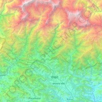
Name: Kaski topographic map, elevation, terrain.
Location: Kaski, Gandaki Province, Nepal (28.07773 83.69944 28.61295 84.27848)
Average elevation: 2,565 m
Minimum elevation: 381 m
Maximum elevation: 8,006 m
Thank you for supporting this site ❤️
Make a donation
Make a donation
Other topographic maps
Click on a map to view its topography, its elevation and its terrain.