Geolocate

Mahottari topographic map

Interactive map

Click on the map to display elevation.

About this map

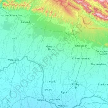
Name: Mahottari topographic map, elevation, terrain.

Location: Mahottari, Madhesh Province, Nepal (26.60168 85.67492 27.16856 85.94552)

Average elevation: 174 m

Minimum elevation: 59 m

Maximum elevation: 1,066 m

Other topographic maps

Click on a map to view its topography, its elevation and its terrain.

Janaknandani

Nepal > Madhesh Province > Dhanusha

Janaknandani, Dhanusha, Madhesh Province, Nepal

Average elevation: 73 m

Mahottari

Nepal > Madhesh Province > Mahottari

Mahottari, Madhesh Province, Nepal

Average elevation: 71 m