
Make a donation
Bhojpur topographic map
Click on the map to display elevation.
Make a donation
Bhojpur
Classified as a hill district, Bhojpur actually spans five of Nepal's eight climate zones. 3% of the district's area is below 300 meters elevation in the Lower Tropical zone and 31% is Upper Tropical from 300 to 1,000 meters. 50% of the land area belongs to the Subtropical Zone between 1,000 and 2,000 meters and 15% is Temperate (2,000 to 3,000 meters). 2% rises higher into the Subalpine Zone.
Make a donation
About this map
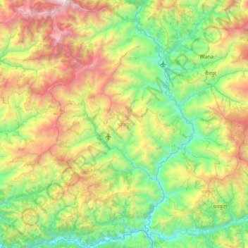
Name: Bhojpur topographic map, elevation, terrain.
Location: Bhojpur, Koshi Province, Nepal (26.88658 86.89476 27.46356 87.27543)
Average elevation: 1,352 m
Minimum elevation: 120 m
Maximum elevation: 4,104 m
Make a donation
Other topographic maps
Click on a map to view its topography, its elevation and its terrain.
Khumjung
Nepal > Koshi Province > Solukhumbu
Khumjung (Nepali: खुम्जुंग) is a village in Khumbu Pasanglhamu rural municipality of Solukhumbu District in Province No. 1 of north-eastern Nepal. It is located in the Khumbu subregion inside Sagarmatha National Park, a world heritage site. The village is at an elevation of 3,790 metres above…
Average elevation: 3,888 m
Mount Everest
Nepal > Koshi Province > Solukhumbu
Mount Everest (Nepali: सगरमाथा, romanized: Sagarmāthā; Tibetan: Chomolungma ཇོ་མོ་གླང་མ; Chinese: 珠穆朗玛峰; pinyin: Zhūmùlǎngmǎ Fēng) is Earth's highest mountain above sea level, located in the Mahalangur Himal sub-range of the Himalayas. The China–Nepal…
Average elevation: 7,850 m