
Thank you for supporting this site ❤️
Make a donation
Make a donation
Laligurans topographic map
Click on the map to display elevation.
Thank you for supporting this site ❤️
Make a donation
Make a donation
About this map
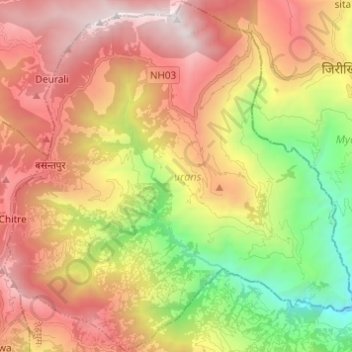
Name: Laligurans topographic map, elevation, terrain.
Location: Laligurans, Tehrathum, Province #1, Nepal (27.07600 87.39184 27.18400 87.51393)
Average elevation: 1,802 m
Minimum elevation: 582 m
Maximum elevation: 2,990 m
Thank you for supporting this site ❤️
Make a donation
Make a donation