
Dhangadhi topographic map
Click on the map to display elevation.
About this map
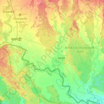
Name: Dhangadhi topographic map, elevation, terrain.
Location: Dhangadhi, Kailali, 10900, Nepal (28.56620 80.53739 28.78462 80.75679)
Average elevation: 178 m
Minimum elevation: 154 m
Maximum elevation: 210 m
Other topographic maps
Click on a map to view its topography, its elevation and its terrain.