
Make a donation
Far-Western Development Region topographic map
Click on the map to display elevation.
Make a donation
Far-Western Development Region
The Far-Western Region covered 19,539 square kilometers. It had nine districts with the regional headquarters at Dipayal, Doti district. The Far-Western Region was remote and developmentally challenged. Some 44% of people in the Far West Hills and 49% in the Himalayan districts lived below the poverty line. The region had limited basic services. The difficult topography complicated development. The region had complex socio-economic structures along with widespread gender- and caste-based discrimination. Traditional systems associated with religion, culture and customs had limited overall development.
Make a donation
About this map
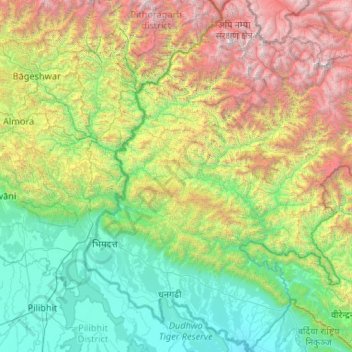
Name: Far-Western Development Region topographic map, elevation, terrain.
Location: Far-Western Development Region, Sudurpashchim Pradesh, Nepal (28.39432 80.05862 30.22044 81.80838)
Average elevation: 1,858 m
Minimum elevation: 139 m
Maximum elevation: 6,892 m
Make a donation
Other topographic maps
Click on a map to view its topography, its elevation and its terrain.
Make a donation
Make a donation
Make a donation
Make a donation
Khumjung
Nepal > Koshi Province > Solukhumbu
Khumjung (Nepali: खुम्जुंग) is a village in Khumbu Pasanglhamu rural municipality of Solukhumbu District in Province No. 1 of north-eastern Nepal. It is located in the Khumbu subregion inside Sagarmatha National Park, a world heritage site. The village is at an elevation of 3,790 metres above…
Average elevation: 3,888 m
Tengboche
Nepal > Solukhumbu > Khumjung > Tengboche
Tengboche is a midway station on the trail to the base camp for the mountain climbers of Mount Everest and other peaks of over 8,000 metres (26,000 ft) elevation; all these areas form part of the entire Khumbu region up to Tibet border with an area of 1,148 square kilometres (443 sq mi) encompassing Sagarmatha…
Average elevation: 3,936 m
Make a donation
Mount Everest
Nepal > Koshi Province > Solukhumbu
Mount Everest (Nepali: सगरमाथा, romanized: Sagarmāthā; Tibetan: Chomolungma ཇོ་མོ་གླང་མ; Chinese: 珠穆朗玛峰; pinyin: Zhūmùlǎngmǎ Fēng) is Earth's highest mountain above sea level, located in the Mahalangur Himal sub-range of the Himalayas. The China–Nepal…
Average elevation: 7,850 m
Make a donation