
丹东市 topographic map
Interactive map
Click on the map to display elevation.
About this map
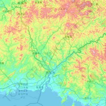
Name: 丹东市 topographic map, elevation, terrain.
Location: 丹东市, 辽宁省, 中国 (39.74624 123.37104 41.15281 125.70199)
Average elevation: 257 m
Minimum elevation: -2 m
Maximum elevation: 1,393 m
丹东地区除东港沿海平原大部分属辽东丘陵地带外,地处长白山脉的余脉。地势由东北向西南逐渐降低。地貌以山地和丘陵为主,按高度和地形特征,可划分为北部中低山区,南部丘陵区,南缘沿海平原区3类地貌单元。山地丘陵占总面积72%,平原占15%,水域占9%,其它占4%。沿海有大鹿岛,獐岛等岛屿。主要水系有:鸭绿江、浑江、瑗河、大洋河。全市最高山是花脖山,海拔1,336.1米,还有青椅山、黄椅山等休眠火山。
Other topographic maps
Click on a map to view its topography, its elevation and its terrain.