
曲家店镇 topographic map
Interactive map
Click on the map to display elevation.
About this map
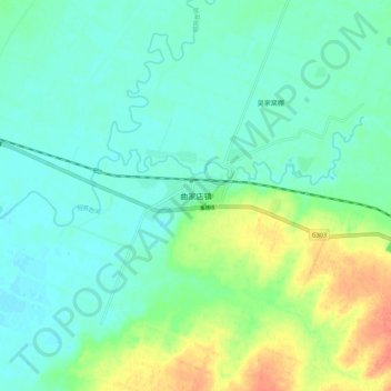
Name: 曲家店镇 topographic map, elevation, terrain.
Location: 曲家店镇, 昌图县, 铁岭市, 辽宁省, 中国 (43.18181 123.88879 43.26181 123.96879)
Average elevation: 119 m
Minimum elevation: 106 m
Maximum elevation: 150 m
Other topographic maps
Click on a map to view its topography, its elevation and its terrain.