
Lidingö kommun topographic map
Interactive map
Click on the map to display elevation.
About this map
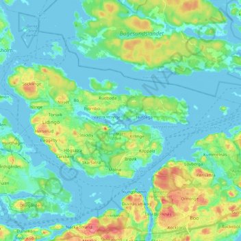
Name: Lidingö kommun topographic map, elevation, terrain.
Location: Lidingö kommun, Stockholm County, Region Svealand, Sweden (59.32430 18.08799 59.40562 18.30339)
Average elevation: 17 m
Minimum elevation: -2 m
Maximum elevation: 70 m
Other topographic maps
Click on a map to view its topography, its elevation and its terrain.
Skövde
Sweden > Västra Götaland County
Skövde has a maritime-continental hybrid climate. The town is influenced by being in the slope of a hill, which leads to warmer overnight lows than in Skara on the western side of the same higher area. In July 2018, Skövde recorded a 22 °C (72 °F) mean during the 2018 European heat wave. This makes it one…
Average elevation: 181 m
Abisko
Permafrost is common around the village albeit this low altitude permafrost is disappearing because of global warming and increased snowfall.
Average elevation: 395 m