
五台县 topographic map
Interactive map
Click on the map to display elevation.
About this map
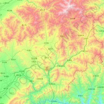
Name: 五台县 topographic map, elevation, terrain.
Location: 五台县, 忻州市, 山西省, 035514, 中国 (38.46839 112.95570 39.08067 113.84916)
Average elevation: 1,355 m
Minimum elevation: 352 m
Maximum elevation: 3,060 m
境东北为五台山,地势东北高,西南低。最高峰北台顶,海拔3058米。
Other topographic maps
Click on a map to view its topography, its elevation and its terrain.