
太原市 topographic map
Interactive map
Click on the map to display elevation.
About this map
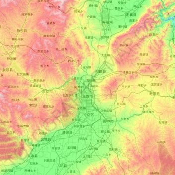
Name: 太原市 topographic map, elevation, terrain.
Location: 太原市, 山西省, 中国 (37.44142 111.50892 38.42085 113.14779)
Average elevation: 1,195 m
Minimum elevation: 550 m
Maximum elevation: 2,376 m
太原市位于黄土高原东部,太原盆地北端,地理坐标为北纬37°27′~38°25′,东经111°30′~113°09′。北、西、东三面环山,中部和南部一角开阔的汾河河谷平原,整个地形北高南低呈簸箕形。海拔最高点为2,670米,最低点为760米,平均海拔800米左右。毗邻忻州市、吕梁市、晋中市、阳泉市。
Other topographic maps
Click on a map to view its topography, its elevation and its terrain.