Geolocate

黄莺乡 topographic map

Interactive map

Click on the map to display elevation.

About this map

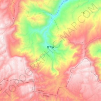
Name: 黄莺乡 topographic map, elevation, terrain.

Location: 黄莺乡, 武隆区, 重庆市, 中国 (29.14498 107.57098 29.28221 107.74798)

Average elevation: 1,223 m

Minimum elevation: 229 m

Maximum elevation: 1,917 m

Other topographic maps

Click on a map to view its topography, its elevation and its terrain.

长坝镇

中国 > 重庆市 > 武隆区

长坝镇, 武隆区, 重庆市, 中国

Average elevation: 835 m

桐梓镇

中国 > 重庆市 > 武隆区

桐梓镇, 武隆区, 重庆市, 中国

Average elevation: 997 m

白马镇

中国 > 重庆市 > 武隆区

白马镇, 武隆区, 重庆市, 中国

Average elevation: 977 m

蒲板

中国 > 重庆市 > 武隆区

蒲板, 武隆区, 重庆市, 中国

Average elevation: 1,036 m

浩口乡

中国 > 重庆市 > 武隆区

浩口乡, 武隆区, 重庆市, 中国

Average elevation: 918 m

芙蓉街道

中国 > 重庆市 > 武隆区 > 芙蓉街道

芙蓉街道, 武隆区, 渝东南武陵山区城镇群区位, 重庆市, 中国

Average elevation: 697 m

仙女山街道

中国 > 重庆市 > 武隆区

仙女山街道, 武隆区, 重庆市, 中国

Average elevation: 1,266 m