
海南岛 topographic map
Interactive map
Click on the map to display elevation.
About this map
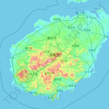
Name: 海南岛 topographic map, elevation, terrain.
Location: 海南岛, 海南省, 中国 (18.15920 108.61254 20.16251 111.04233)
Average elevation: 98 m
Minimum elevation: -3 m
Maximum elevation: 1,768 m
降水方面,受夏季季风影响,岛上降水从东向西减少;受地形影响,降水廣泛集中於東部,西南部降水少,因此位於島內西南部有個著名的莺歌海盐场。
Other topographic maps
Click on a map to view its topography, its elevation and its terrain.