Geolocate

长流镇 topographic map

Interactive map

Click on the map to display elevation.

About this map

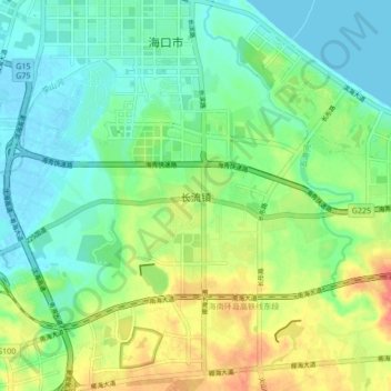
Name: 长流镇 topographic map, elevation, terrain.

Location: 长流镇, 海口市, 海南省, 570311, 中国 (19.97449 110.16221 20.05449 110.24221)

Average elevation: 20 m

Minimum elevation: -3 m

Maximum elevation: 58 m

Other topographic maps

Click on a map to view its topography, its elevation and its terrain.

南亚

中国 > 海南省 > 海口市

南亚, 海口市, 海南省, 中国

Average elevation: 70 m

琼山区

中国 > 海南省 > 海口市

琼山区, 海口市, 海南省, 571138, 中国

Average elevation: 47 m

美兰区

中国 > 海南省 > 海口市

美兰区, 海口市, 海南省, 中国

Average elevation: 27 m

秀英区

中国 > 海南省 > 海口市

秀英区, 海口市, 海南省, 中国

Average elevation: 34 m

南渡江

中国 > 海南省 > 海口市

南渡江, 秀英区, 海口市, 海南省, 571154, 中国

Average elevation: 26 m

海甸河

中国 > 海南省 > 海口市

海甸河, 美兰区, 海口市, 海南省, 570228, 中国

Average elevation: 5 m