Geolocate

兰洋镇 topographic map

Interactive map

Click on the map to display elevation.

About this map

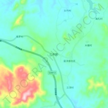
Name: 兰洋镇 topographic map, elevation, terrain.

Location: 兰洋镇, 儋州市, 海南省, 中国 (19.42193 109.62040 19.50193 109.70040)

Average elevation: 213 m

Minimum elevation: 134 m

Maximum elevation: 496 m

Other topographic maps

Click on a map to view its topography, its elevation and its terrain.

茅地村

中国 > 海南省 > 儋州市 > 岛村

茅地村, 岛村, 儋州市, 海南省, 中国

Average elevation: 124 m

光村镇

中国 > 海南省 > 儋州市

光村镇, 儋州市, 海南省, 中国

Average elevation: 15 m

中和镇

中国 > 海南省 > 儋州市

中和镇, 儋州市, 海南省, 中国

Average elevation: 14 m

厦兰社区

中国 > 海南省 > 儋州市

厦兰社区, 儋州市, 海南省, 中国

Average elevation: 6 m

南丰镇

中国 > 海南省 > 儋州市

南丰镇, 儋州市, 海南省, 中国

Average elevation: 185 m

雅星镇

中国 > 海南省 > 儋州市

雅星镇, 儋州市, 海南省, 571727, 中国

Average elevation: 132 m

寨村

中国 > 海南省 > 儋州市

寨村, 儋州市, 海南省, 中国

Average elevation: 52 m

西庆居大海居民小组

中国 > 海南省 > 儋州市 > 大星村

西庆居大海居民小组, 大星村, 儋州市, 海南省, 中国

Average elevation: 103 m

和庆镇

中国 > 海南省 > 儋州市

和庆镇, 儋州市, 海南省, 中国

Average elevation: 149 m

新案江村

中国 > 海南省 > 儋州市 > 东方村

新案江村, 东方村, 儋州市, 海南省, 中国

Average elevation: 17 m

来山村

中国 > 海南省 > 儋州市 > 铁匠村

来山村, 铁匠村, 儋州市, 海南省, 中国

Average elevation: 34 m

儋州市

中国 > 海南省 > 儋州市

儋州市, 海南省, 中国

Average elevation: 150 m