
歙县 topographic map
Interactive map
Click on the map to display elevation.
About this map
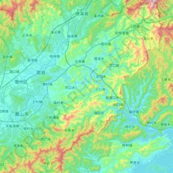
Name: 歙县 topographic map, elevation, terrain.
Location: 歙县, 黄山市, 安徽省, 245200, 中国 (29.50890 118.26278 30.11465 118.89911)
Average elevation: 381 m
Minimum elevation: 93 m
Maximum elevation: 1,749 m
歙县群山环抱,北部为黄山,东部为天目山,东南为白际山,中部为徽州盆地。最高峰为天目山清凉峰,海拔1787米。
Other topographic maps
Click on a map to view its topography, its elevation and its terrain.