
谢岗镇 topographic map
Interactive map
Click on the map to display elevation.
About this map
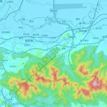
Name: 谢岗镇 topographic map, elevation, terrain.
Location: 谢岗镇, 东莞市, 广东省, 中国 (22.88332 114.07684 23.00435 114.25528)
Average elevation: 147 m
Minimum elevation: 1 m
Maximum elevation: 979 m
谢岗山清水秀,有七万多亩的原始山林和湖泊,处处飘洒着鲜活林木的幽香,海拔898米的东莞第一峰银瓶嘴高耸于此,银瓶山森林公园、崖山森林公园环境优美,是市民悠闲游乐的好去处。
Other topographic maps
Click on a map to view its topography, its elevation and its terrain.