
Make a donation
Solomon Islands topographic map
Click on the map to display elevation.
Make a donation
Solomon Islands
The culture of Solomon Islands reflects the extent of the differentiation and diversity among the groups living within the Solomon Islands archipelago, which lies within Melanesia in the Pacific Ocean, with the peoples distinguished by island, language, topography, and geography. The cultural area includes the nation state of Solomon Islands and the Bougainville Island, which is a part of Papua New Guinea. Solomon Islands includes some culturally Polynesian societies which lie outside the main region of Polynesian influence, known as the Polynesian Triangle. There are seven Polynesian outliers within the Solomon Islands: Anuta, Bellona, Ontong Java, Rennell, Sikaiana, Tikopia, and Vaeakau-Taumako. Solomon Islands arts and crafts cover a wide range of woven objects, carved wood, stone and shell artefacts in styles specific to different provinces..
Make a donation
About this map
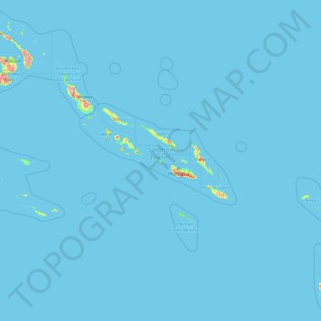
Name: Solomon Islands topographic map, elevation, terrain.
Location: Solomon Islands (-13.24243 155.31906 -4.81279 170.39647)
Average elevation: 7 m
Minimum elevation: 0 m
Maximum elevation: 2,170 m
Make a donation
Other topographic maps
Click on a map to view its topography, its elevation and its terrain.
Gaborone
Botswana > South-East District
Gaborone is situated at 24°39′29″S 25°54′44″E / 24.65806°S 25.91222°E / -24.65806; 25.91222 between Kgale and Oodi Hills, on the Notwane River in the south-eastern corner of Botswana, and 15 kilometres (9.3 mi) from the South African border The city lies at an elevation of 1,010 metres…
Average elevation: 1,032 m
Make a donation
Maunatlala
As time passed by Kgosi Mapena’s eldest son who was named Maunatlala died, the village’ name was changed from Kopung to Maunatlala. Climatic Conditions The climate of Maunatlala area is semi-arid with dry winters and fairly wet summer months, with drought endemic. The average precipitation for the area is…
Average elevation: 878 m
Make a donation
Make a donation
Make a donation
Make a donation
Serule
Botswana > Central District > Serule
The population according to the 2001 census was 2,268 and it is estimated at more than 3000 in the latest 2011 census. The people of Serule Village comprises different ethnicities namely Bangwato, Bakwena, Batalaote, Bakalanga, Bahurutshe and its six wards are Mothoathubega, Borotsi, Mokwena, Botalaote,…
Average elevation: 935 m
Make a donation
Make a donation
Mer de Glace
France > Auvergne-Rhône-Alpes > Upper Savoy > Chamonix-Mont-Blanc
The glacier lies above the Chamonix valley. The pressure within the ice is known to reach at least 30 atmospheres. The Mer de Glace can be considered as originating at an elevation of 2,100 metres (6,900 ft), just north of the Aiguille du Tacul [fr], where it is formed by the confluence of the Glacier de…
Average elevation: 2,322 m
Mount Iliamna
United States > Alaska > Kenai Peninsula Borough
Holocene eruptive activity from Iliamna is little known, but radiocarbon dating seems to indicate at least a few eruptions, all before the European settlement of Alaska. Prehistoric eruptions have been dated to 5050 and 2050 BCE (VEI-4), 450 BCE and 1650. Historically observed eruptions took place in 1867…
Average elevation: 2,360 m
Make a donation
Make a donation
KwaMhlanga
South Africa > Mpumalanga > Nkangala > Thembisile Hani Local Municipality
Average elevation: 1,338 m
Make a donation
Forest Hills
South Africa > KwaZulu-Natal > eThekwini Metropolitan Municipality
Average elevation: 482 m
Make a donation
Kinver Edge
United Kingdom > England > Staffordshire > South Staffordshire > Kinver
Average elevation: 95 m
Mutale
South Africa > Limpopo > Vhembe District Municipality > Mutale Local Municipality
Average elevation: 755 m
Make a donation
Kigali
Rwanda > Kigali City > Nyarugenge District
Kigali is located in the centre of Rwanda, at 1°57′S 30°4′E. Like the rest of Rwanda it uses Central Africa Time, and is two hours ahead of Coordinated Universal Time (UTC+02:00) throughout the year. The city is coterminous with the province of Kigali, one of the five provinces of Rwanda introduced in…
Average elevation: 1,530 m
Mamelodi
South Africa > Gauteng > City of Tshwane Metropolitan Municipality
Average elevation: 1,319 m
Make a donation
Nahoon River
South Africa > Eastern Cape > Buffalo City Metropolitan Municipality > KuGompo City
Average elevation: 65 m
Make a donation
Welkom
South Africa > Free State > Lejweleputswa District Municipality
Koppie Alleen is the only hill near Welkom and therefore is aptly named for its oddity. The terrain elevation above sea level is 1435 metres. The largest water catchment is the Sand River to the south-east of Welkom in Virginia's direction. Large saline pans such as Flamingo Pan and Theronia Pan are situated…
Average elevation: 1,341 m
Make a donation
Вранићки Тарајиш
Serbia > City of Belgrade > Barajevo Urban Municipality > Vranic
Average elevation: 162 m
Dandenong Ranges
Australia > Victoria > Melbourne
The topography consists of a series of ridges dissected by deeply cut streams. Sheltered gullies in the south of the range are home to temperate rain forest, fern gullies and mountain ash forest Eucalyptus regnans, whereas the drier ridges and exposed northern slopes are covered by dry sclerophyll forest of…
Average elevation: 456 m
K2
Pakistan > Gilgit-Baltistan > Shigar District
Also occasionally known as Mount Godwin-Austen, other nicknames for K2 are The King of Mountains and The Mountaineers' Mountain, as well as The Mountain of Mountains after prominent Italian climber Reinhold Messner titled his book about K2 the same. Although the summit of Everest is at a higher altitude, K2 is…
Average elevation: 7,474 m
Make a donation
Wellington
South Africa > Western Cape > Cape Winelands District Municipality > Drakenstein Local Municipality
Average elevation: 168 m
Overlooking the steppe and sand dunes
Mongolia > Ömnögovi > Sevrey > Sevrey
Average elevation: 1,796 m
Make a donation
Ernakulam
India > Kerala > Kanayannur
The Ernakulam District is situated in Central Kerala in India. Ernakulam is located at the geographic coordinates of 9°58′53.8″N 76°17′59.6″E / 9.981611°N 76.299889°E / 9.981611; 76.299889 and at an elevation of 22.36 m (73.4 ft) above the mean sea level.
Average elevation: 6 m
Make a donation
Ghorahi
Nepal > Lumbini Province > Dang
Ghorahi is the main town of the Rapti Zone and also the headquarters of the Dang district. It is located at an elevation of 2,300 feet (700 m) in the Mahabharat-Chure hill region.
Average elevation: 865 m
Heilbron
South Africa > Free State > Fezile Dabi District Municipality > Ngwathe Local Municipality
Average elevation: 1,559 m
Make a donation
Africa
Africa's topography is a complex tapestry of plateaus, mountains, valleys, and deserts. The continent is dominated by vast plateaus, with elevations averaging around 1,000 meters (3,281 feet), especially prominent in the south and east. The Ethiopian Highlands, often referred to as the "Roof of Africa," rise…
Average elevation: 462 m
Make a donation
KuGompo City
South Africa > Eastern Cape > Buffalo City Metropolitan Municipality
Average elevation: 72 m
Make a donation
Toubkal
Morocco > cercle d'Asni > Asni
Toubkal, also Jbel Toubkal or Jebel Toubkal, is a mountain in southwestern Morocco, located in the Toubkal National Park. At 4,167 m (13,671 ft), it is the highest peak in Morocco, the Atlas Mountains, North Africa and the Arab world. Located 63 km (39 mi) south of the city of Marrakesh, and visible from it,…
Average elevation: 3,616 m
Nikiti
Greece > Macedonia and Thrace > Chalkidiki Regional Unit > Sithonia Municipal Unit
Average elevation: 64 m
Volksrust
South Africa > Mpumalanga > Gert Sibande District Municipality > Pixley Ka Seme Local Municipality > Volksrust
Average elevation: 1,688 m
Make a donation
The Matterhorn
United States > Connecticut > Northwest Hills Planning Region > Canaan
Average elevation: 462 m
Mount Fuji
Japan > Sunto County > Oyama
Mount Fuji (富士山・富士の山, Fujisan, Fuji no Yama) is an active stratovolcano located on the Japanese island of Honshu, with a summit elevation of 3,776.24 m (12,389 ft 3 in). It is the highest mountain in Japan, the second-highest volcano on any Asian island (after Mount Kerinci on the Indonesian…
Average elevation: 3,264 m
Nilambur
The 2,554 m (8,379 ft) m high Mukurthi peak, which is situated in the border of Nilambur Taluk and Ooty Taluk, and is also the fifth-highest peak in South India as well as the third-highest in Kerala after Anamudi (2,696 m [8,845 ft]) and Meesapulimala (2,651 m [8,698 ft]), is the highest point of elevation in…
Average elevation: 33 m
Graskop
South Africa > Mpumalanga > Ehlanzeni District Municipality > Thaba Chweu Local Municipality
Average elevation: 1,385 m
Make a donation
Phiphidi Waterfall
South Africa > Limpopo > Vhembe District Municipality > Thulamela Local Municipality
Average elevation: 781 m
Ghazni
Ghazni's climate is transitional between a cold semi-arid climate (Köppen climate classification BSk) and a hot-summer humid continental climate (Dsa). It has cold, snowy winters and warm, dry summers. Precipitation is low and mostly falls in winter (as snow) and spring (as rain). Winters are very cold, with…
Average elevation: 2,341 m
Make a donation
Make a donation