
Thank you for supporting this site ❤️
Make a donation
Make a donation
Ramotswa topographic map
Click on the map to display elevation.
Thank you for supporting this site ❤️
Make a donation
Make a donation
About this map
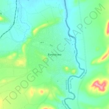
Name: Ramotswa topographic map, elevation, terrain.
Location: Ramotswa, South-East District, Botswana (-24.91104 25.82516 -24.83104 25.90516)
Average elevation: 1,043 m
Minimum elevation: 1,016 m
Maximum elevation: 1,126 m
Thank you for supporting this site ❤️
Make a donation
Make a donation
Other topographic maps
Click on a map to view its topography, its elevation and its terrain.