
Kgatleng District topographic map
Interactive map
Click on the map to display elevation.
About this map
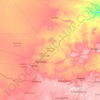
Name: Kgatleng District topographic map, elevation, terrain.
Location: Kgatleng District, Botswana (-26.74478 23.82048 -21.54478 29.02048)
Average elevation: 1,120 m
Minimum elevation: 526 m
Maximum elevation: 1,962 m
Other topographic maps
Click on a map to view its topography, its elevation and its terrain.
Gaborone
Gaborone is situated at 24°39′29″S 25°54′44″E / 24.65806°S 25.91222°E / -24.65806; 25.91222 between Kgale and Oodi Hills, on the Notwane River in the south-eastern corner of Botswana, and 15 kilometres (9.3 mi) from the South African border. The city lies at an elevation of 1,010 metres…
Average elevation: 1,034 m
Gaborone
Gaborone is situated at 24°39′29″S 25°54′44″E / 24.65806°S 25.91222°E / -24.65806; 25.91222 between Kgale and Oodi Hills, on the Notwane River in the south-eastern corner of Botswana, and 15 kilometres (9.3 mi) from the South African border. The city lies at an elevation of 1,010 metres…
Average elevation: 1,032 m
North-East District
Most parts of Botswana have tableland slopes sliding from east to west. It is predominantly savannah, with tall grasses, bushes, and trees. The region has an average elevation of around 915 m (3,002 ft) above sea level. The annual precipitation is around 65 cm (26 in), most of which is received during the…
Average elevation: 1,077 m
Gaborone
Gaborone is situated at 24°39′29″S 25°54′44″E / 24.65806°S 25.91222°E / -24.65806; 25.91222 between Kgale and Oodi Hills, on the Notwane River in the south-eastern corner of Botswana, and 15 kilometres (9.3 mi) from the South African border. The city lies at an elevation of 1,010 metres…
Average elevation: 1,034 m
Chobe District
Kasane, Chobe National Park, Seboba Water Rapids, Pandamatenga Farms, Lesoma Memorial Monument, Kasane Hot Springs and Chobe River are the major tourist attractions in the district. Most part of Botswana has tableland slopes sliding from east to west. The region has an average elevation of around 915 m (3,002…
Average elevation: 981 m
North-West District
The region has an average elevation of around 915 m (3,002 ft) above the mean sea level. The vegetation type is Savannah, with tall grasses, bushes and trees. The annual precipitation is around 650 mm (26 in), most of which is received during the summer season from November to May.
Average elevation: 979 m
North-East District
Most parts of Botswana have tableland slopes sliding from east to west. It is predominantly savannah, with tall grasses, bushes, and trees. The region has an average elevation of around 915 m (3,002 ft) above sea level. The annual precipitation is around 65 cm (26 in), most of which is received during the…
Average elevation: 1,077 m
Central District
Most part of Botswana has tableland slopes sliding from east to west. The region has an average elevation of around 915 m (3,002 ft) above the mean sea level. The vegetation type is Savannah, with tall grasses, bushes and trees. The annual precipitation is around 65 cm (26 in), most of which is received during…
Average elevation: 1,006 m
North-West District
The region has an average elevation of around 915 m (3,002 ft) above the mean sea level. The vegetation type is Savannah, with tall grasses, bushes and trees. The annual precipitation is around 650 mm (26 in), most of which is received during the summer season from November to May.
Average elevation: 979 m
Southern District
In the south, Southern borders the North West Province of South Africa. Domestically, it borders South-East District in east, Kweneng District in north, Kgalagadi District and south west. Southern District is traversed by the northwesterly line of equal latitude and longitude. Most part of Botswana has…
Average elevation: 1,139 m
Ghanzi District
In the west, Ghanzi borders the Omaheke Region of Namibia. Domestically, it borders the following districts: North-West on the north, Central on the east, Kweneng on the southeast, Kgalagadi on the south. Ghanzi is traversed by the northwesterly line of equal latitude and longitude. This region is largely…
Average elevation: 1,071 m
North-East District
Most parts of Botswana have tableland slopes sliding from east to west. It is predominantly savannah, with tall grasses, bushes, and trees. The region has an average elevation of around 915 m (3,002 ft) above sea level. The annual precipitation is around 65 cm (26 in), most of which is received during the…
Average elevation: 1,077 m
Central District
Most part of Botswana has tableland slopes sliding from east to west. The region has an average elevation of around 915 m (3,002 ft) above the mean sea level. The vegetation type is Savannah, with tall grasses, bushes and trees. The annual precipitation is around 65 cm (26 in), most of which is received during…
Average elevation: 1,006 m
Kweneng District
Kweneng is the only district without a foreign border. It borders Central District in northeast, Kgatleng District on the east, South-East District in southeast, Southern District in south, Kgalagadi District in the west, Ghanzi District in the north. The region is traversed by the northwesterly line of equal…
Average elevation: 1,083 m