
Thank you for supporting this site ❤️
Make a donation
Make a donation
Kgale Hill topographic map
Click on the map to display elevation.
Thank you for supporting this site ❤️
Make a donation
Make a donation
About this map
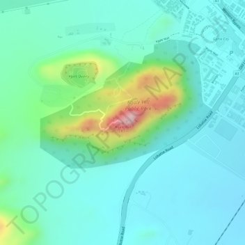
Name: Kgale Hill topographic map, elevation, terrain.
Location: Kgale Hill, Gaborone, Botswana (-24.69593 25.86704 -24.69583 25.86714)
Average elevation: 1,064 m
Minimum elevation: 1,002 m
Maximum elevation: 1,272 m
Thank you for supporting this site ❤️
Make a donation
Make a donation
Other topographic maps
Click on a map to view its topography, its elevation and its terrain.