
Thank you for supporting this site ❤️
Make a donation
Make a donation
Kalamare topographic map
Click on the map to display elevation.
Thank you for supporting this site ❤️
Make a donation
Make a donation
About this map
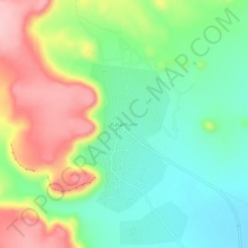
Name: Kalamare topographic map, elevation, terrain.
Location: Kalamare, Central District, Botswana (-22.95443 26.55077 -22.91443 26.59077)
Average elevation: 1,212 m
Minimum elevation: 1,140 m
Maximum elevation: 1,325 m
Thank you for supporting this site ❤️
Make a donation
Make a donation
Other topographic maps
Click on a map to view its topography, its elevation and its terrain.