
Mount Fuji topographic map
Click on the map to display elevation.
Mount Fuji
Mount Fuji (富士山・富士の山, Fujisan, Fuji no Yama) is an active stratovolcano located on the Japanese island of Honshu, with a summit elevation of 3,776.24 m (12,389 ft 3 in). It is the highest mountain in Japan, the second-highest volcano on any Asian island (after Mount Kerinci on the Indonesian island of Sumatra), and the seventh-highest peak of an island on Earth. Mount Fuji last erupted from 1707 to 1708.
About this map
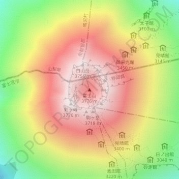
Name: Mount Fuji topographic map, elevation, terrain.
Location: Mount Fuji, Oyama, Sunto County, Shizuoka Prefecture, Japan (35.36279 138.73072 35.36289 138.73082)
Average elevation: 3,264 m
Minimum elevation: 2,656 m
Maximum elevation: 3,757 m