
Africa topographic map
Interactive map
Click on the map to display elevation.
Africa
Africa's topography is a complex tapestry of plateaus, mountains, valleys, and deserts. The continent is dominated by vast plateaus, with elevations averaging around 1,000 meters (3,281 feet), especially prominent in the south and east. The Ethiopian Highlands, often referred to as the "Roof of Africa," rise to formidable heights, with peaks such as Ras Dejen reaching 4,550 meters (14,928 feet). The Great Rift Valley, a significant geological feature, stretches from the Red Sea down to Mozambique, creating deep depressions hosting some of Africa's largest lakes, including Lake Tanganyika and Lake Malawi, and marked by volcanic mountains such as Mount Kilimanjaro, Africa's highest point at 5,895 metres (19,341 ft) and Mount Kenya. In the northwest, the Atlas Mountains extend through Morocco, Algeria, and Tunisia, with Mount Toubkal standing as the range's highest point at 4,167 meters (13,671 feet). Contrasting these elevations, the Sahara Desert sprawls across North Africa, characterized by expansive sand dunes and rocky plateaus. The southern part of Africa includes the Kalahari Desert and the Drakensberg Mountains, which rise steeply from the plains. This diverse terrain influences the continent's climate, biodiversity, and human settlements.
About this map
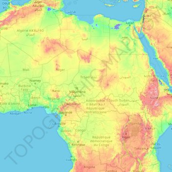
Name: Africa topographic map, elevation, terrain.
Location: Africa (-13.49757 -7.24219 36.50243 42.75781)
Average elevation: 462 m
Minimum elevation: -415 m
Maximum elevation: 4,436 m
Other topographic maps
Click on a map to view its topography, its elevation and its terrain.
Serbia
Ancient mountains in the southeast corner of the country belong to the Rilo-Rhodope Mountain system. Elevation ranges from the Midžor peak of the Balkan Mountains at 2,169 metres (7,116 feet) (the highest peak in Serbia, excluding Kosovo) to the lowest point of just 17 metres (56 feet) near the Danube river…
Average elevation: 492 m
Zurich
Switzerland > Zurich > District Zurich
On its west side, the Limmat valley is flanked by the wooded heights of the Albis chain, which runs along the western border. The Uetliberg is, with 869 m (2,851 ft) above sea level, the highest elevation of the surrounding area. Its summit can be reached easily by the Uetlibergbahn. From the platform of the…
Average elevation: 499 m
Nepal
Nepal is divided into three principal physiographic belts known as Himal–Pahad–Terai. Himal is the mountain region containing snow and situated in the Great Himalayan Range; it makes up the northern part of Nepal. It contains the highest elevations in the world including 8,848.86 metres (29,032 ft) height…
Average elevation: 2,604 m
Contra Costa County
In prehistoric times, particularly the Miocene epoch, portions of the landforms now in the area (then marshy and grassy savanna) were populated by a wide range of now extinct mammals, known in modern times by the fossil remains excavated in the southern part of the county. In the northern part of the county,…
Average elevation: 108 m
Falmouth
United States > Massachusetts > Barnstable County
Falmouth's topography is similar to the rest of Cape Cod's, with many small ponds, creeks, and inlets surrounded by the pines and oaks of the Cape and often rocky beachfront. Falmouth's southern shore is notable for a series of ponds and rivers spaced very closely together, all of which travel some distance…
Average elevation: 7 m
Williamson County
The area is divided into two regions by the Balcones Escarpment, which runs through the center from north to south along a line from Jarrell to Georgetown to Round Rock. The county's western half is an extension of the Western Plains and considered to be within the eastern fringes of Texas Hill Country; it has…
Average elevation: 222 m
Haslemere
United Kingdom > England > Surrey > Waverley
Many of the roads in the area originated as medieval tracks and owing to the local topography, are narrow, twisting and steep. The principal route through Haslemere is the A286, which connects the town with Godalming and Grayswood (to the north) and with Midhurst (to the south). The A287 runs south from…
Average elevation: 150 m
Solomon Islands
The culture of Solomon Islands reflects the extent of the differentiation and diversity among the groups living within the Solomon Islands archipelago, which lies within Melanesia in the Pacific Ocean, with the peoples distinguished by island, language, topography, and geography. The cultural area includes the…
Average elevation: 7 m
Hobart
Light frost occurs most years, though air frosts are uncommon. Although Hobart itself rarely receives snow due to the foehn effect, the adjacent kunanyi / Mount Wellington is frequently seen with a snowcap throughout the year. During the 20th century, the city itself has received snowfalls at sea level on…
Average elevation: 179 m
Vlaska
Serbia > Central Serbia > Pomoravlje Administrative District > Cuprija Municipality
Average elevation: 138 m
Maglic
Serbia > Vojvodina > South Backa Administrative District > Backi Petrovac Municipality
Average elevation: 83 m
Area D (Popkum/Bridal Falls/Wahleach)
Canada > British Columbia > Fraser Valley Regional District
Average elevation: 948 m
Adelaide
Australia > South Australia > Adelaide City Council
Based on the ideas of Edward Gibbon Wakefield about colonial reform, Robert Gouger petitioned the British government to create a new colony in Australia, resulting in the passage of the South Australia Act 1834. Physical establishment of the colony began with the arrival of the first British colonisers in…
Average elevation: 146 m
Ho Chi Minh City
The city is located in the south-eastern region of Vietnam, 1,760 km (1,090 mi) south of Hanoi. The average elevation is 5 m (16 ft) above sea level for the city centre and 16 m (52 ft) for the suburb areas. It borders Tây Ninh Province and Bình Dương Province to the north, Đồng Nai Province and Bà…
Average elevation: 26 m
Bahrain
Average elevation: 6 m
Muntinlupa
Muntinlupa's terrain is relatively flat to sloping towards the east along the lake. Gentle rolling hills occupy the western part of the city, with elevation increasing up to 60 meters (200 ft) and above towards its southwest portion.
Average elevation: 21 m
Kisumu
Kisumu's elevation is 1,131 m (3,711 ft) and is about 320 km (200 mi) northwest of Nairobi, on the shores of Lake Victoria. It lies at the northeastern edge of the Winam Gulf, a long, shallow arm that protrudes from the main body of Lake Victoria. Kisumu is 24 km (15 mi) south of the equator and has, due to…
Average elevation: 1,310 m
Duga Poljana
Serbia > Central Serbia > Zlatibor Administrative District > Sjenica Municipality
Average elevation: 1,132 m
Tivat
Montenegro > Tivat Municipality
Although it is the youngest town in the Boka region, Tivat has a number of tourist sites. Renaissance Summer House Buca in the centre of city, Ostrvo Cvijeća (Flowers’ Island) with sacred monuments, Gornja Lastva, the old nucleus at an altitude of 300 m (984.25 ft), the magnificent sandy beach at Plavi…
Average elevation: 60 m
Podgorica
Montenegro > Podgorica Capital City
In contrast to most of Montenegro, Podgorica lies in a mainly flat area at the northern end of the Zeta plain, at an elevation of 40 m (130 ft). The only exceptions are hills which overlook the city. The most significant is 130.3 m (427 ft) high Gorica Hill (pronounced [ˈɡǒrit͜sa]), city's namesake, which…
Average elevation: 105 m
Amarillo
United States > Texas > Potter County
Extreme temperatures range from −16 °F (−26.7 °C) on February 12, 1899 to 111 °F (43.9 °C) on June 26, 2011, but lows do not typically dip to 0 °F or −17.8 °C in most years, while highs above 100 °F or 37.8 °C are seen on 4.7 days on average. On average, there are 5.9 days of lows at or below 10…
Average elevation: 1,098 m
Bradenton
United States > Florida > Manatee County
Bradenton was affected by World War II like many other cities in Florida and the United States. During the war, Manatee County had its own Civil Defense battalion in it with two subunits existing in Bradenton and another for nearby Manatee. A recreational center was opened in March 1942 at a building on the…
Average elevation: 5 m
Baltimore
Baltimore is in north-central Maryland on the Patapsco River, close to where it empties into the Chesapeake Bay. Baltimore is located on the fall line between the Piedmont Plateau and the Atlantic coastal plain, which divides Baltimore into "lower city" and "upper city". Baltimore's elevation ranges from sea…
Average elevation: 47 m
Žabljak
Montenegro > Žabljak Municipality
Žabljak is the seat of Žabljak Municipality (2011 population: 3,569). The town is in the centre of the Durmitor mountain region and with an altitude of 1,456 metres, it is the highest situated Balkan town.
Average elevation: 1,461 m
Pljevlja
Montenegro > Pljevlja Municipality
The town lies at an altitude of 770 m (2,530 ft). In the Middle Ages, Pljevlja had been a crossroad of the important commercial roads and cultural streams, with important roads connecting the littoral with the Balkan interior. In 2023, the municipality of Pljevlja had a population of 24,542, while the city…
Average elevation: 845 m
Šavnik
Montenegro > Šavnik Municipality
Šavnik (Cyrillic: Шавник, pronounced [ʃǎv̞niːk]) is a town in Montenegro in the northern region and administrative center of the Šavnik Municipality. It is located at the confluence of three rivers - Bukovica, Bijela and Šavnik, at an altitude of 840 meters. It is the lowest lying settlement in…
Average elevation: 1,021 m
Brava
Cape Verde > Brava > Furna
North of Brava are several uninhabited islets; the largest ones are Ilhéu de Cima and Ilhéu Grande. Monte Fontainhas is the highest point on the island, reaching 976 metres elevation.
Average elevation: 212 m
Mojkovac
Montenegro > Mojkovac Municipality
The municipality of Mojkovac covers an area of 367 km2 (142 sq mi) and according to the number of inhabitants (10 015 / 2003g) belongs among the smaller municipalities in Montenegro. The city resort is located at an altitude of 853 m (2,799 ft). Its mathematical position is determined by geographical…
Average elevation: 898 m
Ribeira Grande de Santiago (Cidade Velha)
Cape Verde > Ribeira Grande de Santiago
Average elevation: 56 m
Saint Petersburg
The elevation of Saint Petersburg ranges from the sea level to its highest point of 175.9 m (577 ft) at the Orekhovaya Hill in the Duderhof Heights in the south. Part of the city's territory west of Liteyny Prospekt is no higher than 4 m (13 ft) above sea level, and has suffered from numerous floods. Floods in…
Average elevation: 17 m
Italy
Conditions on the coast are different from those in the interior, particularly during winter when the higher altitudes tend to be cold, wet, and often snowy. The coastal regions have mild winters, and hot and generally dry summers; lowland valleys are hot in summer. Winter temperatures vary from 0 °C (32 °F)…
Average elevation: 293 m
Aylesbury
United Kingdom > England > Buckinghamshire
Aylesbury is immediately southeast of the upper River Thame that flows past Thame to Dorchester on Thames and is partly sited on the two northernmost outcrops of Portland stone in England bisected by a small stream, Bear Brook which gives a relatively prominent position in relation to the terrain of all near,…
Average elevation: 85 m
New Jersey
High Point in Montague Township, Sussex County is the state's highest elevation at 1,803 feet (550 m) above sea level. The state's highest prominence is Kitty Ann Mountain in Morris County, rising 892 feet (272 m). The Palisades are a line of steep cliffs on the west side of the Hudson River in Bergen and…
Average elevation: 72 m
Golovo
Serbia > Central Serbia > Zlatibor Administrative District > Cajetina Municipality
Average elevation: 857 m