
Thank you for supporting this site ❤️
Make a donation
Make a donation
Paris topographic map
Click on the map to display elevation.
Thank you for supporting this site ❤️
Make a donation
Make a donation
About this map
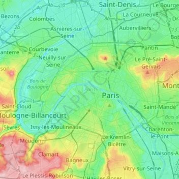
Name: Paris topographic map, elevation, terrain.
Location: Paris, Metropolitan France, France (48.81558 2.22412 48.90216 2.46976)
Average elevation: 62 m
Minimum elevation: 21 m
Maximum elevation: 186 m
Thank you for supporting this site ❤️
Make a donation
Make a donation
Other topographic maps
Click on a map to view its topography, its elevation and its terrain.
Thank you for supporting this site ❤️
Make a donation
Make a donation
Thank you for supporting this site ❤️
Make a donation
Make a donation