Serbia topographic map
Click on the map to display elevation.
Serbia
Ancient mountains in the southeast corner of the country belong to the Rilo-Rhodope Mountain system. Elevation ranges from the Midžor peak of the Balkan Mountains at 2,169 metres (7,116 feet) (the highest peak in Serbia, excluding Kosovo) to the lowest point of just 17 metres (56 feet) near the Danube river at Prahovo. The largest lake is Đerdap Lake (163 square kilometres (63 sq mi)) and the longest river passing through Serbia is the Danube (587.35 kilometres (364.96 mi)).
About this map
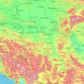
Name: Serbia topographic map, elevation, terrain.
Location: Serbia (42.23145 18.81499 46.19028 23.00631)
Average elevation: 492 m
Minimum elevation: 0 m
Maximum elevation: 2,544 m
Other topographic maps
Click on a map to view its topography, its elevation and its terrain.
Gaborone
Botswana > South-East District
Gaborone is situated at 24°39′29″S 25°54′44″E / 24.65806°S 25.91222°E / -24.65806; 25.91222 between Kgale and Oodi Hills, on the Notwane River in the south-eastern corner of Botswana, and 15 kilometres (9.3 mi) from the South African border The city lies at an elevation of 1,010 metres…
Average elevation: 1,032 m



Maunatlala
As time passed by Kgosi Mapena’s eldest son who was named Maunatlala died, the village’ name was changed from Kopung to Maunatlala. Climatic Conditions The climate of Maunatlala area is semi-arid with dry winters and fairly wet summer months, with drought endemic. The average precipitation for the area is…
Average elevation: 878 m






Serule
Botswana > Central District > Serule
The population according to the 2001 census was 2,268 and it is estimated at more than 3000 in the latest 2011 census. The people of Serule Village comprises different ethnicities namely Bangwato, Bakwena, Batalaote, Bakalanga, Bahurutshe and its six wards are Mothoathubega, Borotsi, Mokwena, Botalaote,…
Average elevation: 935 m



Abbotsford
United Kingdom > England > West Sussex > Mid Sussex > Burgess Hill > Goddards' Green
Average elevation: 39 m



Skardu
Pakistan > Gilgit-Baltistan > Skardu District
Skardu (Urdu: سکردو, romanised: skardū, Balti: སྐར་མདོ, pronounced [skərduː]) is a city located in Pakistan-administered Gilgit-Baltistan in the disputed Kashmir region. Skardu serves as the capital of Skardu District and the Baltistan Division. It is situated at an average elevation of…
Average elevation: 3,423 m


Worcester
South Africa > Western Cape > Cape Winelands District Municipality > Breede Valley Local Municipality
Worcester is located at an elevation of 220 metres (720 ft) and can be reached by road either travelling on the N1 highway through the Huguenot Tunnel or by driving through spectacular mountain passes. From Cape Town Du Toitskloof, from Wellington Bainskloof, from Malmesbury, Western Cape Nieuwekloof, from…
Average elevation: 252 m



Chattogram
Bangladesh > Chattogram Division > Chittagong City
Chittagong lies at 22°20′06″N 91°49′57″E / 22.33500°N 91.83250°E / 22.33500; 91.83250. It straddles the coastal foothills of the Chittagong Hill Tracts in south-eastern Bangladesh. The Karnaphuli River runs along the southern banks of the city, including its central business district. The…
Average elevation: 6 m


Mount Arjuna
Canada > British Columbia > Central Coast Regional District > Area C (Hagensborg/Talchako/Atnarko)
Average elevation: 2,127 m


Playa Bonita
Spain > Andalusia > Costa del Sol Occidental > La Perla-Torremuelle > Santana
Average elevation: 42 m

Norton Juxta Twycross
United Kingdom > England > Leicestershire > Hinckley and Bosworth
Average elevation: 109 m

Punta Arenas
Chile > Magallanes and Chilean Antarctica Region > Provincia de Magallanes
Average elevation: 122 m


Mount Siple
Average elevation: 2,887 m






Rakwana
Sri Lanka > Sabaragamuwa Province
Located at an elevation of 464 m (1,522 ft), north of Sinharaja Mountains, on the A17 highway. It is 12 km (7.5 mi) from Rakwana-Deniyaya on the way to Galle. It also has roads leading to Embilipitiya and Kalawana. Rakwana acts as one of the gateways for the famous Sinharaja Forest reserve.
Average elevation: 609 m



Радовићи
Serbia > Kolubara Administrative District > Gornje Leskovice > Илићи
Average elevation: 675 m


Asia
Average elevation: 563 m


Bcharreh Cedars of God Forest
Lebanon > North Governorate > El Arz
Time, along with the exploitation of the wood and the effects of climate change, has led to a decrease in the number of cedar trees in Lebanon. However, Lebanon is still widely known for its cedar tree history, as they are the emblem of the country and the symbol of the Lebanese flag. The remaining trees…
Average elevation: 1,959 m