
Thank you for supporting this site ❤️
Make a donation
Make a donation
Thalgau topographic map
Click on the map to display elevation.
Thank you for supporting this site ❤️
Make a donation
Make a donation
About this map
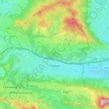
Name: Thalgau topographic map, elevation, terrain.
Location: Thalgau, Bezirk Salzburg-Umgebung, Salzburg, 5303, Austria (47.80847 13.18105 47.89260 13.31221)
Average elevation: 704 m
Minimum elevation: 503 m
Maximum elevation: 1,284 m
Thank you for supporting this site ❤️
Make a donation
Make a donation
Other topographic maps
Click on a map to view its topography, its elevation and its terrain.
Wallersee
Austria > Salzburg > Bezirk Salzburg-Umgebung > Seekirchen am Wallersee > Fischtaging
Average elevation: 531 m
Thank you for supporting this site ❤️
Make a donation
Make a donation
Thank you for supporting this site ❤️
Make a donation
Make a donation
Thank you for supporting this site ❤️
Make a donation
Make a donation