
Nepal topographic map
Click on the map to display elevation.
Nepal
Nepal is divided into three principal physiographic belts known as Himal–Pahad–Terai. Himal is the mountain region containing snow and situated in the Great Himalayan Range; it makes up the northern part of Nepal. It contains the highest elevations in the world including 8,848.86 metres (29,032 ft) height Mount Everest (Sagarmāthā in Nepali) on the border with China. Seven other of the world's "eight-thousanders" are in Nepal or on its border with Tibet: Lhotse, Makalu, Cho Oyu, Kangchenjunga, Dhaulagiri, Annapurna and Manaslu. Pahad is the mountain region that does not generally contain snow. The mountains vary from 800 to 4,000 metres (2,600 to 13,100 ft) in altitude, with progression from subtropical climates below 1,200 metres (3,900 ft) to alpine climates above 3,600 metres (11,800 ft). The Lower Himalayan Range, reaching 1,500 to 3,000 metres (4,900 to 9,800 ft), is the southern limit of this region, with subtropical river valleys and "hills" alternating to the north of this range. Population density is high in valleys but notably less above 2,000 metres (6,600 ft) and very low above 2,500 metres (8,200 ft), where snow occasionally falls in winter. The southern lowland plains or Terai bordering India are part of the northern rim of the Indo-Gangetic Plain. Terai is the lowland region containing some hill ranges. The plains were formed and are fed by three major Himalayan rivers: the Koshi, the Narayani, and the Karnali as well as smaller rivers rising below the permanent snowline. This region has a subtropical to tropical climate. The outermost range of the foothills called Sivalik Hills or Churia Range, cresting at 700 to 1,000 metres (2,300 to 3,280 ft), marks the limits of the Gangetic Plain. Broad, low valleys called Inner Terai Valleys (Bhitri Tarai Upatyaka) lie north of these foothills in several places.
About this map
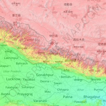
Name: Nepal topographic map, elevation, terrain.
Location: Nepal (26.34776 80.05708 30.44695 88.20153)
Average elevation: 2,604 m
Minimum elevation: 20 m
Maximum elevation: 8,152 m
Other topographic maps
Click on a map to view its topography, its elevation and its terrain.
Antrogna
Italy > Piedmont > Verbano-Cusio-Ossola > Calasca-Castiglione > Calasca
Average elevation: 979 m
Maunatlala
As time passed by Kgosi Mapena’s eldest son who was named Maunatlala died, the village’ name was changed from Kopung to Maunatlala. Climatic Conditions The climate of Maunatlala area is semi-arid with dry winters and fairly wet summer months, with drought endemic. The average precipitation for the area is…
Average elevation: 878 m
Gaborone
Botswana > South-East District
Gaborone is situated at 24°39′29″S 25°54′44″E / 24.65806°S 25.91222°E / -24.65806; 25.91222 between Kgale and Oodi Hills, on the Notwane River in the south-eastern corner of Botswana, and 15 kilometres (9.3 mi) from the South African border The city lies at an elevation of 1,010 metres…
Average elevation: 1,032 m
Serule
Botswana > Central District > Serule
The population according to the 2001 census was 2,268 and it is estimated at more than 3000 in the latest 2011 census. The people of Serule Village comprises different ethnicities namely Bangwato, Bakwena, Batalaote, Bakalanga, Bahurutshe and its six wards are Mothoathubega, Borotsi, Mokwena, Botalaote,…
Average elevation: 935 m
Mbombela (Nelspruit)
South Africa > Mpumalanga > Ehlanzeni District Municipality
Average elevation: 842 m
Allingtown
United States > Connecticut > South Central Connecticut Planning Region > West Haven
Average elevation: 26 m
Simikot
Nepal > Karnali Province > Humla
Lying at an altitude of just over 2,900 metres or 9,500 feet on a gentle slope high above the Humla Karnali River, Simikot lies on an ancient trade-cum-pilgrimage route to Mount Kailash. Mount Kailash is located in the Purang County of the Tibetan Autonomous Region, China, which borders Humla district of Nepal…
Average elevation: 3,100 m
Burgersfort
South Africa > Limpopo > Sekhukhune District Municipality > Greater Tubatse Local Municipality
Average elevation: 810 m
Kilimanjaro
The mountain was incorporated into Kilimanjaro National Park in 1973. As one of the Seven Summits, Kilimanjaro is a major hiking and climbing destination. There are seven established routes to Uhuru Peak, the mountain's highest point. Although not as technically challenging as similar mountains, the prominence…
Average elevation: 1,537 m
Marloth Park
South Africa > Mpumalanga > Ehlanzeni District Municipality > Nkomazi
Average elevation: 220 m
Velddrif
South Africa > Western Cape > West Coast District Municipality > Bergrivier Local Municipality
Average elevation: 8 m
Nordegg
Canada > Alberta > Clearwater County
Nordegg has a subarctic climate (Dfc) which can be considered a subalpine climate due to its altitude with locations on the same latitude having warmer climates. Summers are mild, with a few warm days sprinkled in here and there, while winters are cold and snowy.
Average elevation: 1,475 m
Gradačac
Bosnia and Herzegovina > Federation of Bosnia and Herzegovina > Town of Gradačac
Average elevation: 169 m
Europe
In general, Europe is not just colder towards the north compared to the south, but it also gets colder from the west towards the east. The climate is more oceanic in the west and less so in the east. This can be illustrated by the following table of average temperatures at locations roughly following the 64th,…
Average elevation: 223 m
Maroun Al Ras
Lebanon > Nabatieh Governorate
The village was the scene of the Battle of Maroun al-Ras, a major confrontation between the Israeli Army and Hezbollah fighters during the 2006 Lebanon War. The village is at an elevation of 911 meters (2,989 feet), and is strategically important as it overlooks the surrounding towns. During the battle, the…
Average elevation: 767 m
Golija
Serbia > Moravica Administrative District > Ivanjica Municipality
There are four lakes on the mountain. At the altitude of 900 metres (3,000 ft) there are the Košanin Lakes, on the Crepuljnik's northern slopes. A natural phenomenon, where the water rescinds during the rain, and the water level rise in dry periods. There are two lakes, Great and Little Košanin Lake. They…
Average elevation: 1,631 m