Contra Costa County topographic map
Click on the map to display elevation.
Contra Costa County
In prehistoric times, particularly the Miocene epoch, portions of the landforms now in the area (then marshy and grassy savanna) were populated by a wide range of now extinct mammals, known in modern times by the fossil remains excavated in the southern part of the county. In the northern part of the county, significant coal and sand deposits were formed in even earlier geologic eras. Other areas of the county have ridges exposing ancient but intact (not fossilized) seashells, embedded in sandstone layers alternating with limestone. Layers of volcanic ash ejected from geologically recent but now extinct volcanoes, compacted and now tilted by compressive forces, may be seen at the site of some road excavations. This county is an agglomeration of several distinct geologic terranes, as is most of the greater San Francisco Bay Area, which is one of the most geologically complex regions in the world. The great local mountain Mount Diablo has been formed and continues to be elevated by compressive forces resulting from the action of plate tectonics and at its upper reaches presents ancient seabed rocks scraped from distant oceanic sedimentation locations and accumulated and lifted by these great forces. Younger deposits at middle altitudes include pillow lavas, the product of undersea volcanic eruptions.
About this map
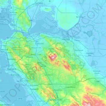
Name: Contra Costa County topographic map, elevation, terrain.
Location: Contra Costa County, California, United States (37.71848 -122.44148 38.10451 -121.53427)
Average elevation: 108 m
Minimum elevation: -8 m
Maximum elevation: 1,136 m
Other topographic maps
Click on a map to view its topography, its elevation and its terrain.

San Francisco Bay Area
United States > California > San Francisco
The San Francisco Bay Area is characterized by a diverse and dynamic topography shaped by geological processes over millions of years. This region features a combination of coastal plains, steep hills, and rugged mountains, all influenced by the tectonic activity associated with the nearby San Andreas Fault…
Average elevation: 113 m
San Fernando Valley
United States > California > Los Angeles County > Los Angeles
Average elevation: 496 m

San Francisco Bay Area
United States > California > San Francisco
The borders of the San Francisco Bay Area are not officially delineated, and the unique development patterns influenced by the region's topography, as well as unusual commute patterns caused by the presence of three central cities and employment centers located in various suburban locales, has led to…
Average elevation: 113 m
El Dorado Hills
United States > California > El Dorado County > Cameron Park
El Dorado Hills (EDH), as defined by the 2010 census-designated place (CDP), is at the western border of El Dorado County, between the City of Folsom and the unincorporated community of Cameron Park. The northern limits of the CDP are Folsom Lake and the South Fork of the American River, where river rafters…
Average elevation: 254 m



Pine Mountain Club
United States > California > Kern County
Pine Mountain Club has an area of 16.7 square miles (43.25 km2). It ranges from 4,901 to 6,400 feet (1,494 to 1,951 m) in elevation. The community sits in a deep valley of the San Emigdio Mountains, on the San Andreas fault. It is surrounded by Los Padres National Forest. The settlement lies between Apache…
Average elevation: 1,867 m



Oakhurst
United States > California > Madera County
Oakhurst is located on the Fresno River 3 miles (5 km) south-southwest of Yosemite Forks, at an elevation of 2,274 feet (693 m). Its coordinates are 37°19′41″N 119°38′58″W / 37.32806°N 119.64944°W / 37.32806; -119.64944. It is located at the junction of state highways 41 and 49, at the…
Average elevation: 837 m
Twain Harte
United States > California > Tuolumne County
Twain Harte is situated in Tuolumne County along Highway 108 at an elevation of 3,640 feet (1,110 m).
Average elevation: 1,123 m
General Sherman Tree
United States > California > Tulare County
General Sherman is a giant sequoia (Sequoiadendron giganteum) tree located at an elevation of 2,109 m (6,919 ft) above sea level in the Giant Forest of Sequoia National Park in Tulare County, in the U.S. state of California. By volume, it is the largest known living single-stem tree on Earth.
Average elevation: 2,114 m
Quincy
United States > California > Plumas County > Quincy
Quincy has a Mediterranean climate (Köppen Csb) though its inland location and altitude makes it more continental and wetter than usual for this type, with very heavy snowfalls sometimes occurring in winter – the record being 133 inches (337.8 cm) in the very wet January 1916. Although summer days are hot…
Average elevation: 1,274 m


Mono City
United States > California > Mono County
Mono City is an unincorporated community and census-designated place (CDP) in Mono County, California, United States. It lies north of Mono Lake at the base of the Sierra Nevada at the junction of U.S. Route 395 and California State Route 167, at an elevation of 6,768 feet (2,063 m). The ZIP Code is 93541;…
Average elevation: 2,060 m

El Dorado
United States > California > El Dorado County
El Dorado (Spanish for "The Golden") is an unincorporated community in El Dorado County, California. It is located 4 miles (6.4 km) southwest of Placerville, at an elevation of 1608 feet (490 m). The population was 4,096 at the 2000 census. The town is registered as California Historical Landmark #486. The ZIP…
Average elevation: 511 m

Woodacre
United States > California > Marin County
The community is located at 38°00′46″N 122°38′43″W / 38.01278°N 122.64528°W / 38.01278; -122.64528 in the eastern half of the San Geronimo Valley of central Marin County. San Geronimo and Lagunitas-Forest Knolls are to its west. Woodacre is located 8 miles (13 km) south-southwest of…
Average elevation: 246 m


Mammoth Mountain
United States > California > Mono County > Mammoth Lakes
Mammoth Mountain is a lava dome complex in Mono County, California. It lies in the southwestern corner of the Long Valley Caldera and consists of about 12 rhyodacite and dacite overlapping domes. These domes formed in a long series of eruptions from 110,000 to 57,000 years ago, building a volcano that reaches…
Average elevation: 3,011 m


Pollock Pines
United States > California > El Dorado County > Pollock Pines
Pollock Pines is a census-designated place (CDP) in El Dorado County, California, United States. It is part of the Sacramento–Arden-Arcade–Roseville Metropolitan Statistical Area. Pollock Pines lies at an elevation of 3,980 feet (1,210 m) in the Sierra Nevada. The population was 6,871 at the 2010 census,…
Average elevation: 1,118 m



Santa Cruz Mountains
United States > California > Santa Clara County
The Santa Cruz Mountains are a region of great biological diversity, encompassing cool, moist coastal ecosystems as well as warm, dry chaparral. Much of the area in the Santa Cruz mountains is considered temperate rainforest. In valleys and moist ocean-facing slopes some of the southernmost coast redwoods…
Average elevation: 230 m


Murphys
United States > California > Calaveras County
"MURPHY'S CAMP is a curious old mining-town in Calaveras County, at an elevation of 2,400 feet (730 m) above the sea, situated like a nest in the center of a rough, gravelly region, rich in gold. Granites, slates, lavas, limestone, iron ores, quartz veins, auriferous gravels, remnants of dead fire-rivers and…
Average elevation: 702 m
Ramona
United States > California > San Diego County
In January 2006, Ramona Valley was designated the country's 162nd American Viticultural Area (AVA) by the Alcohol and Tobacco Tax and Trade Bureau, which recognized the area for its distinctive microclimate, elevation, and soil attributes.
Average elevation: 469 m
San Diego
United States > California > San Diego County > San Diego
The climate in San Diego, like most of Southern California, often varies significantly over short geographical distances, resulting in microclimates. In San Diego, this is mostly because of the city's topography (the Bay, and the numerous hills, mountains, and canyons). Frequently, particularly during the "May…
Average elevation: 57 m
McKinleyville
United States > California > Humboldt County
McKinleyville (formerly Minorsville) is a census-designated place (CDP) in Humboldt County, California McKinleyville is located 5.25 miles (8.4 km) north of Arcata, at an elevation of 141 feet (43 m). The population was 15,177 at the 2010 census, up from 13,599 at the time of the 2000 census.
Average elevation: 49 m

Live Oak
United States > California > Santa Cruz County > Live Oak
Live Oak is a census-designated place (CDP) in Santa Cruz County, California between the cities of Santa Cruz and Capitola and north of the former Union Pacific railroad. Live Oak sits at an elevation of 102 feet (31 m). The population was 17,038 at the 2020 census. The population of the greater Live Oak area,…
Average elevation: 47 m




Markleeville
United States > California > Alpine County
Markleeville hosts an annual bicycle ride called the Death Ride - Tour of the California Alps. The route goes over five passes for a total distance of 129 miles and over 15,000 feet of elevation gain. In 2010 3,500 riders participated and 2,417 completed the full course of 5 mountain passes.
Average elevation: 1,788 m

Big Bear City
United States > California > San Bernardino County
It is estimated that the Serrano natives first settled in Big Bear between 1,500 and 2,000 years ago. The Serranos had both winter and summer settlements throughout the area. While their winter village was located in Lucerne Valley, they relocated to villages in the San Bernardino mountains during summer, as…
Average elevation: 2,167 m



Garberville
United States > California > Humboldt County
Garberville is a census-designated place in Humboldt County, California. It is located on the South Fork of the Eel River 52 miles (84 km) south-southeast of Eureka, at an elevation of 535 feet (163 m). The population was 913 at the 2010 United States Census. It is approximately 200 miles (320 km) north of San…
Average elevation: 198 m

Avila Beach
United States > California > San Luis Obispo County
The beach is less than 0.5 miles (0.8 km) long and sheltered in San Luis Bay, which is formed by Point San Luis on the west and Fossil Point on the east. Avila Beach faces south and the 600 foot elevation of Point San Luis breaks the prevailing northwesterly winds. It is therefore usually warmer than the other…
Average elevation: 46 m
Cajon Pass
United States > California > San Bernardino County
Cajon Pass (/kəˈhoʊn/; Spanish: Puerto del Cajón or Paso del Cajón) is a mountain pass between the San Bernardino Mountains to the east and the San Gabriel Mountains to the west in Southern California. Created by the movements of the San Andreas Fault, it has an elevation of 3,777 ft (1,151 m). Located in…
Average elevation: 1,169 m


Greeley Hill
United States > California > Mariposa County
Greeley Hill is a census-designated place in Mariposa County, California, United States. Greeley Hill sits at an elevation of 3,153 feet (961 m) in the foothills of the Sierra Nevada. The 2020 United States census reported Greeley Hill's population as 927.
Average elevation: 987 m

Universal City Overlook
United States > California > Los Angeles County > Los Angeles
Average elevation: 278 m



Walnut Grove
United States > California > Sacramento County
Walnut Grove's location has made it the site of a rare collection of very tall radio and television transmission towers. The first major tower here was the KXTV/KOVR/KCRA Tower built in 1962, which dominated the skyline for over twenty years with its 1,548 foot height. In 1985 the old tower was joined by…
Average elevation: 1 m

White Mountain Peak
United States > California > Mono County
It is the fourteenth most topographically prominent peak in the contiguous United States. White Mountain Peak is one of only two fourteeners (peaks above 14,000 feet) in California that are not in the Sierra Nevada, the other being Mount Shasta at the far northern end of the state in the Cascade Range. It is…
Average elevation: 3,880 m
Newport Beach
United States > California > Orange County > Newport Beach > Newport Beach
Newport Beach extends in elevation from sea level to the 1,161 ft (354 m) summit of Signal Peak in the San Joaquin Hills, but the official elevation is 25 ft (7.6 m) above sea level at a location of 33°37′0″N 117°53′51″W / 33.61667°N 117.89750°W / 33.61667; -117.89750 (33.616671, −117.897604).
Average elevation: 9 m

San Fernando Valley
United States > California > Los Angeles County > Los Angeles
Average elevation: 496 m