
Thank you for supporting this site ❤️
Make a donation
Make a donation
Freedom topographic map
Click on the map to display elevation.
Thank you for supporting this site ❤️
Make a donation
Make a donation
About this map
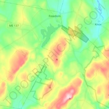
Name: Freedom topographic map, elevation, terrain.
Location: Freedom, Waldo County, Maine, 04941, United States (44.44939 -69.39601 44.54459 -69.28921)
Average elevation: 180 m
Minimum elevation: 89 m
Maximum elevation: 338 m
Thank you for supporting this site ❤️
Make a donation
Make a donation
Other topographic maps
Click on a map to view its topography, its elevation and its terrain.