
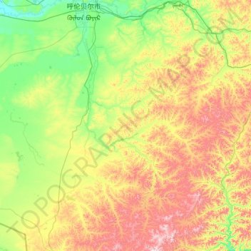
鄂温克族自治旗 topographic map
Interactive map
Click on the map to display elevation.
About this map
Name: 鄂温克族自治旗 topographic map, elevation, terrain.
Location: 鄂温克族自治旗, 呼伦贝尔市, 内蒙古自治区, 中国 (47.54881 118.79729 49.28885 121.16161)
Average elevation: 871 m
Minimum elevation: 581 m
Maximum elevation: 1,692 m
自治旗地处大兴安岭山地西北坡,处于大兴安岭山地向呼伦贝尔平原的过渡地段,地势由东南向西北倾斜。平均海拔高度800~1000米。最高点是东南部山地的伊和高古达山,海拔1706.6米,最低处在伊敏河谷地,海拔602米。
Other topographic maps
Click on a map to view its topography, its elevation and its terrain.