
牙克石市 topographic map
Interactive map
Click on the map to display elevation.
About this map
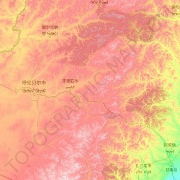
Name: 牙克石市 topographic map, elevation, terrain.
Location: 牙克石市, 呼伦贝尔市, 内蒙古自治区, 中国 (47.66079 120.45835 50.87154 122.49214)
Average elevation: 737 m
Minimum elevation: 161 m
Maximum elevation: 1,655 m
牙克石市(蒙古语:ᠶᠠᠭᠰᠢᠬᠣᠲᠠ,西里尔字母:Ягши хот)是中华人民共和国内蒙古自治区的一个县级市,由呼伦贝尔市代管,原名喜桂图旗。位於大兴安岭北段,呼伦贝尔草原东端,南北长352公里,东西宽147公里,海拔600米至1000米之间。面积27590平方公里,是中国土地面积第六大的县级市,人口35.22万,民族24个。
Other topographic maps
Click on a map to view its topography, its elevation and its terrain.