
Make a donation
Botswana topographic map
Click on the map to display elevation.
Make a donation
Botswana
Botswana (/bɒtˈswɑːnə/ (listen), also UK: /bʊt-, bʊˈtʃw-/), officially the Republic of Botswana (Setswana: Lefatshe la Botswana, [lɪˈfatsʰɪ la bʊˈtswana]), is a landlocked country in Southern Africa. Botswana is topographically flat, with approximately 70 percent of its territory being the Kalahari Desert. It is bordered by South Africa to the south and southeast, Namibia to the west and north, and Zimbabwe to the northeast. It is connected to Zambia across the short Zambezi River border by the Kazungula Bridge.
Make a donation
About this map
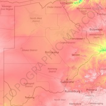
Name: Botswana topographic map, elevation, terrain.
Location: Botswana (-26.90701 19.99865 -17.77814 29.37389)
Average elevation: 1,078 m
Minimum elevation: 483 m
Maximum elevation: 1,990 m
Make a donation
Other topographic maps
Click on a map to view its topography, its elevation and its terrain.
Make a donation
Maunatlala
As time passed by Kgosi Mapena’s eldest son who was named Maunatlala died, the village’ name was changed from Kopung to Maunatlala. Climatic Conditions The climate of Maunatlala area is semi-arid with dry winters and fairly wet summer months, with drought endemic. The average precipitation for the area is…
Average elevation: 878 m
Make a donation
Make a donation
Gaborone
Botswana > South-East District
Gaborone is situated at 24°39′29″S 25°54′44″E / 24.65806°S 25.91222°E / -24.65806; 25.91222 between Kgale and Oodi Hills, on the Notwane River in the south-eastern corner of Botswana, and 15 kilometres (9.3 mi) from the South African border The city lies at an elevation of 1,010 metres…
Average elevation: 1,032 m
Make a donation
Serule
Botswana > Central District > Serule
The population according to the 2001 census was 2,268 and it is estimated at more than 3000 in the latest 2011 census. The people of Serule Village comprises different ethnicities namely Bangwato, Bakwena, Batalaote, Bakalanga, Bahurutshe and its six wards are Mothoathubega, Borotsi, Mokwena, Botalaote,…
Average elevation: 935 m
Make a donation
Maroun Al Ras
Lebanon > Nabatieh Governorate
The village was the scene of the Battle of Maroun al-Ras, a major confrontation between the Israeli Army and Hezbollah fighters during the 2006 Lebanon War. The village is at an elevation of 911 meters (2,989 feet), and is strategically important as it overlooks the surrounding towns. During the battle, the…
Average elevation: 767 m
Make a donation
Kollam
Cosmas Indicopleustes, a Greek Nestorian sailor, in his book the Christian Topography who visited the Malabar Coast in 550, mentions an enclave of Christian believers in Male (Malabar Coast). He writes, "In the island of Tabropane (Ceylon), there is a church of Christians, and clerics and faithful. Likewise at…
Average elevation: 11 m
Nkanini
South Africa > Eastern Cape > O.R. Tambo District Municipality > King Sabata Dalindyebo Local Municipality
Average elevation: 713 m
Make a donation
Sasolburg
South Africa > Free State > Fezile Dabi District Municipality > Metsimaholo Local Municipality
Sasolburg is at a high altitude with a fairly dry climate and large seasonal temperature variation. It is situated on the banks of the Vaal River, which separates the Free State from the former Transvaal Province, and is not far from the Vaal Dam where excellent windsurfing spots can be found.
Average elevation: 1,469 m
Västerås
Västerås is predominantly known as an industrial city, but also a retailing and logistics city. The city wants to distinguish itself as Västerås – Mälarstaden, meaning "Västerås—the city by Lake Mälaren", in order to attract tourists and new residents, as well as students to the local university,…
Average elevation: 28 m
Make a donation
Redhill
United Kingdom > England > Surrey > Reigate and Banstead
To the north, the town joins with the village of Merstham, north of which there is a "wind gap" in the chalk hills of the North Downs, at an elevation of 120 metres (390 feet) above sea level, through which the A23 road heads in from London. Geologists have speculated that there may once have been a…
Average elevation: 107 m
Colesberg
South Africa > Northern Cape > Pixley ka Seme District Municipality > Umsobomvu Local Municipality
Average elevation: 1,392 m
Eshowe
South Africa > KwaZulu-Natal > King Cetswayo District Municipality > uMlalazi Local Municipality
Average elevation: 457 m
Make a donation
Dodoma
The official capital since 1996, Dodoma was envisaged as the first non-monumental capital city as opposed to the monumentality and hierarchy of other planned capital cities such as Abuja, Yamoussoukro, Brasília and Washington, D.C. It rejected geometrical forms such as grid iron and radial plans as…
Average elevation: 1,143 m
Make a donation
KwaMhlanga
South Africa > Mpumalanga > Nkangala > Thembisile Hani Local Municipality
Average elevation: 1,338 m
Make a donation
Make a donation
Make a donation
Make a donation
Welkom
South Africa > Free State > Lejweleputswa District Municipality
Koppie Alleen is the only hill near Welkom and therefore is aptly named for its oddity. The terrain elevation above sea level is 1435 metres. The largest water catchment is the Sand River to the south-east of Welkom in Virginia's direction. Large saline pans such as Flamingo Pan and Theronia Pan are situated…
Average elevation: 1,341 m
Make a donation
Mer de Glace
France > Auvergne-Rhône-Alpes > Upper Savoy > Chamonix-Mont-Blanc
The glacier lies above the Chamonix valley. The pressure within the ice is known to reach at least 30 atmospheres. The Mer de Glace can be considered as originating at an elevation of 2,100 metres (6,900 ft), just north of the Aiguille du Tacul [fr], where it is formed by the confluence of the Glacier de…
Average elevation: 2,322 m
Ernakulam
India > Kerala > Kanayannur
The Ernakulam District is situated in Central Kerala in India. Ernakulam is located at the geographic coordinates of 9°58′53.8″N 76°17′59.6″E / 9.981611°N 76.299889°E / 9.981611; 76.299889 and at an elevation of 22.36 m (73.4 ft) above the mean sea level.
Average elevation: 6 m
Mount Iliamna
United States > Alaska > Kenai Peninsula Borough
Holocene eruptive activity from Iliamna is little known, but radiocarbon dating seems to indicate at least a few eruptions, all before the European settlement of Alaska. Prehistoric eruptions have been dated to 5050 and 2050 BCE (VEI-4), 450 BCE and 1650. Historically observed eruptions took place in 1867…
Average elevation: 2,360 m
Make a donation
Make a donation
Forest Hills
South Africa > KwaZulu-Natal > eThekwini Metropolitan Municipality
Average elevation: 482 m
Nahoon River
South Africa > Eastern Cape > Buffalo City Metropolitan Municipality > KuGompo City
Average elevation: 65 m
Make a donation
Dandenong Ranges
Australia > Victoria > Melbourne
The topography consists of a series of ridges dissected by deeply cut streams. Sheltered gullies in the south of the range are home to temperate rain forest, fern gullies and mountain ash forest Eucalyptus regnans, whereas the drier ridges and exposed northern slopes are covered by dry sclerophyll forest of…
Average elevation: 456 m
Nikiti
Greece > Macedonia and Thrace > Chalkidiki Regional Unit > Sithonia Municipal Unit
Average elevation: 64 m
Make a donation
Make a donation
Mamelodi
South Africa > Gauteng > City of Tshwane Metropolitan Municipality
Average elevation: 1,319 m
Mutale
South Africa > Limpopo > Vhembe District Municipality > Mutale Local Municipality
Average elevation: 755 m
Kigali
Rwanda > Kigali City > Nyarugenge District
Kigali is located in the centre of Rwanda, at 1°57′S 30°4′E. Like the rest of Rwanda it uses Central Africa Time, and is two hours ahead of Coordinated Universal Time (UTC+02:00) throughout the year. The city is coterminous with the province of Kigali, one of the five provinces of Rwanda introduced in…
Average elevation: 1,530 m
Make a donation
Kinver Edge
United Kingdom > England > Staffordshire > South Staffordshire > Kinver
Average elevation: 95 m
Africa
Africa's topography is a complex tapestry of plateaus, mountains, valleys, and deserts. The continent is dominated by vast plateaus, with elevations averaging around 1,000 meters (3,281 feet), especially prominent in the south and east. The Ethiopian Highlands, often referred to as the "Roof of Africa," rise…
Average elevation: 462 m
Make a donation
Kopaonik
Serbia > Rasina Administrative District > Brus Municipality
Kopaonik (Serbian Cyrillic: Копаоник; Albanian: Kopaoniku) is a mountain range located in Kosovo and Serbia. The highest point of this mountain range is the Pančić's Peak with an altitude of 2,017 m (6,617 ft). The central part of the Kopaonik plateau was declared a national park in 1981 which today…
Average elevation: 1,733 m
KuGompo City
South Africa > Eastern Cape > Buffalo City Metropolitan Municipality
Average elevation: 72 m
Make a donation
K2
Pakistan > Gilgit-Baltistan > Shigar District
Also occasionally known as Mount Godwin-Austen, other nicknames for K2 are The King of Mountains and The Mountaineers' Mountain, as well as The Mountain of Mountains after prominent Italian climber Reinhold Messner titled his book about K2 the same. Although the summit of Everest is at a higher altitude, K2 is…
Average elevation: 7,474 m
Make a donation
Make a donation