
Maroun Al Ras topographic map
Click on the map to display elevation.
Maroun Al Ras
The village was the scene of the Battle of Maroun al-Ras, a major confrontation between the Israeli Army and Hezbollah fighters during the 2006 Lebanon War. The village is at an elevation of 911 meters (2,989 feet), and is strategically important as it overlooks the surrounding towns. During the battle, the village was partly occupied by Israel, which claimed it was a stronghold for Hezbollah and one of the launching points for rocket attacks on northern Israel. There are reports that control of the village was contested at the time of the ceasefire. After-battle reports claimed the IDF troops never fully secured the border area and that Maroun al-Ras was never fully taken.
About this map
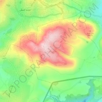
Name: Maroun Al Ras topographic map, elevation, terrain.
Average elevation: 767 m
Minimum elevation: 617 m
Maximum elevation: 945 m
Other topographic maps
Click on a map to view its topography, its elevation and its terrain.
Klayaa
Lebanon > Nabatieh Governorate
The village sits on a ridge at an elevation estimated between 650 and 700 meters (2,130–2,300 ft) above sea level.[4][5][6] Its position places it within the hilly landscape of the Upper Galilee region, an area characterized by rolling highlands and valleys typical of southern Lebanese terrain. Al-Qlaiaah…
Average elevation: 521 m
Kafr Kila
Lebanon > Nabatieh Governorate
The total population of the village is about 14,500. The occupants' number increases dramatically during summer. Its altitude is around 700 m from sea level.
Average elevation: 563 m