
百丈镇 topographic map
Interactive map
Click on the map to display elevation.
About this map
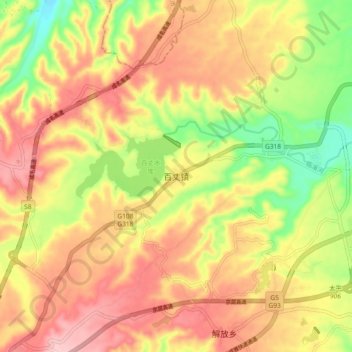
Name: 百丈镇 topographic map, elevation, terrain.
Location: 百丈镇, 名山区, 雅安市, 四川省, 中国 (30.14405 103.19170 30.22405 103.27170)
Average elevation: 724 m
Minimum elevation: 622 m
Maximum elevation: 805 m
Other topographic maps
Click on a map to view its topography, its elevation and its terrain.