
岚安乡 topographic map
Interactive map
Click on the map to display elevation.
About this map
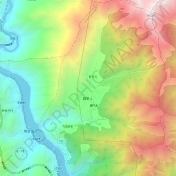
Name: 岚安乡 topographic map, elevation, terrain.
Location: 岚安乡, 泸定县, 甘孜藏族自治州, 四川省, 626100, 中国 (29.98626 102.19062 30.08766 102.27770)
Average elevation: 2,689 m
Minimum elevation: 1,328 m
Maximum elevation: 4,836 m
Other topographic maps
Click on a map to view its topography, its elevation and its terrain.